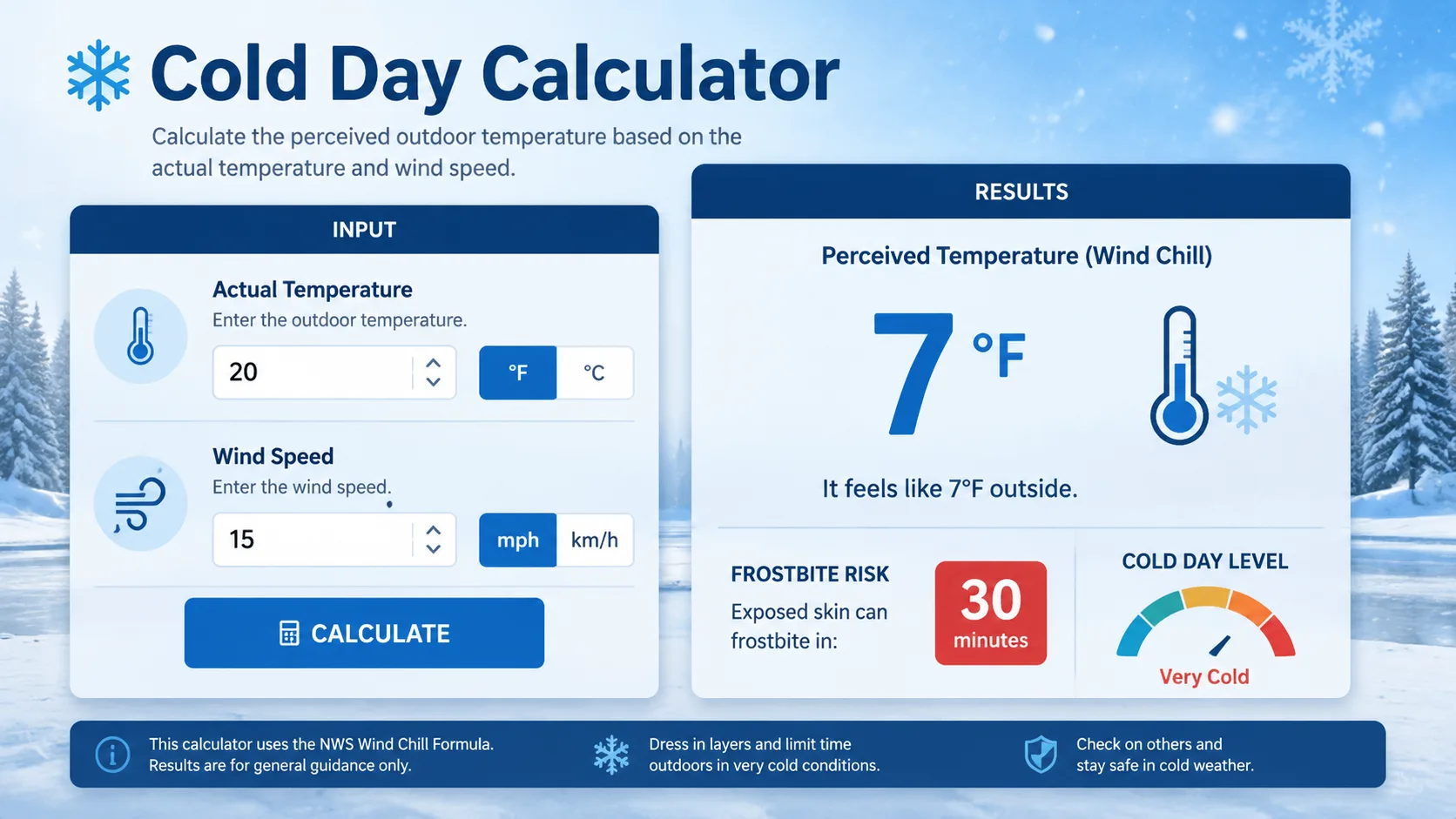
A cold day calculator tells you exactly how dangerous the outside air really is by combining temperature and wind speed into one simple number. Instead of guessing whether it feels cold enough to cancel school, delay a bus route, or skip a morning run, you get a science backed answer in seconds.
This guide walks through the exact formula behind every cold day calculator, shows you how to use one step by step, and includes real worked examples. By the end, you will know precisely what temperature and wind combination counts as a genuine cold day, and why wind matters more than the thermometer.
What Is a Cold Day Calculator?
A cold day calculator is a small tool built around one core idea: cold does not just depend on temperature. It depends on how fast heat leaves your skin, and wind is the main driver of that speed.
The calculator takes two inputs, air temperature and wind speed, and returns a wind chill value, sometimes called the feels like temperature. That single number tells you how quickly frostbite or serious discomfort can set in.
Most modern tools built for parents, teachers, and outdoor workers also translate that number into a plain language risk level, and many flag whether the result falls into a range that typically triggers a school delay, closure, or safety advisory in your area.
Cold Day Calculator vs Snow Day Calculator: What Is the Difference?
Many websites blend these two tools together, but they answer different questions. A snow day calculator estimates the chance schools close because of falling or accumulated snow, road conditions, and storm timing.
A cold day calculator focuses purely on temperature and wind, the two inputs behind wind chill. Schools frequently close on clear, sunny mornings when the air is simply too cold for kids to safely wait at a bus stop, even without a single flake of snow on the ground.
Knowing which tool answers your actual question saves time. If the sky is clear but the air feels brutal, a cold day calculator gives you a far more relevant answer than a snowfall forecast ever could.
Why Wind Chill Matters More Than the Thermometer
Air temperature alone rarely tells the full story in winter. Two mornings can both read 10°F on the thermometer, yet one feels tolerable and the other feels dangerous, purely because of wind speed.
The National Weather Service defines wind chill as the rate at which your body loses heat when exposed to cold air combined with wind. It is not a measurement of how cold the air actually is. It measures how fast that cold air pulls warmth away from exposed skin.
How Wind Strips Away Body Heat
Your skin naturally holds a thin layer of warm air close to its surface, acting like an invisible jacket. Calm air lets that layer stay in place.
Wind constantly sweeps that warm layer away and replaces it with colder air, forcing your body to work harder to reheat the surface. The stronger the wind, the faster this cycle repeats, and the faster you lose core warmth.
This is exactly why a cold day calculator that ignores wind speed and only looks at temperature will always underestimate real world risk.
The Cold Day Calculator Formula Explained
Every reputable cold day calculator online is built on one standardized equation: the National Weather Service Wind Chill Temperature Index, introduced in 2001 after research with human test subjects replaced an older, less accurate model from the 1940s.
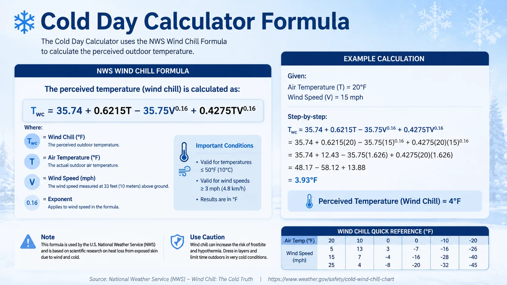
The Official NWS Wind Chill Formula
T = Air temperature in Fahrenheit
V = Sustained wind speed in mph, measured at 5 feet above ground
Break it down in plain language:
- Start with a fixed baseline of 35.74
- Add a portion of the actual air temperature
- Subtract a wind based penalty that grows as wind speed increases
- Add back a smaller adjustment that depends on both temperature and wind together
The result is a single feels like number that a cold day calculator displays instantly, without you ever touching a calculator app yourself.
A Brief History of the Wind Chill Index
The concept dates back to 1945, when Antarctic explorers Paul Siple and Charles Passel measured how quickly water froze in a plastic container exposed to wind. That early model overstated real cooling because it measured an object, not living skin.
In 2001, the National Weather Service and Environment Canada jointly replaced it with the current formula, calibrated using human test subjects walking on a treadmill in a wind tunnel. This is the version every accurate cold day calculator uses today.
When the Formula Applies (and When It Does Not)
This formula only works under specific conditions. The National Weather Service designed it for air temperatures at or below 50°F and wind speeds above 3 mph.
Above that temperature, wind actually helps your body cool through evaporation, so it does not create a dangerous cooling effect. Below 3 mph, air is considered calm enough that wind chill simply equals the actual air temperature.
Humidity is deliberately left out of the formula. NWS testing on human subjects found humidity changed the result by less than one degree, so the agency simplified the model by removing it entirely.
How to Use a Cold Day Calculator: Step-by-Step Guide
- Find your current or forecast temperature. Check a trusted local source or weather app for the raw air temperature, not the feels like number, since you want clean inputs for the calculator.
- Find your sustained wind speed. Look specifically for sustained wind in mph or km/h, not gusts. Gusts are short bursts and will overstate your real exposure.
- Enter both numbers into the calculator. Most tools use sliders or simple input boxes for temperature and wind speed.
- Add your location type if asked. Some calculators ask whether you live in a snow heavy, moderate, or rare snow region to fine tune closure likelihood alongside wind chill.
- Read your wind chill result. The calculator returns a feels like temperature, plus on most tools, a plain language risk level such as low, moderate, high, or extreme.
- Compare against local thresholds. Check your specific school district or workplace cold weather policy, since actual closure thresholds vary by region and infrastructure.
Cold Day Calculator Chart: Wind Chill and Frostbite Time
Numbers are easier to act on when you can see them. The chart below shows how quickly frostbite can develop on exposed skin as wind chill drops, based on National Weather Service frostbite guidance.
Frostbite Onset Time vs Wind Chill Temperature 0 10 20 30 Minutes to Frostbite 30 min 0°F to -10°F 20 min -10°F to -25°F 12 min -25°F to -45°F 5 min Below -45°F
| Wind Chill Range | Frostbite Time on Exposed Skin | Risk Level |
|---|---|---|
| 0°F to -10°F (-18°C to -23°C) | About 30 minutes | Moderate |
| -10°F to -25°F (-23°C to -32°C) | 10 to 30 minutes | High |
| -25°F to -45°F (-32°C to -43°C) | 10 to 15 minutes | Very High |
| Below -45°F (-43°C) | Under 5 minutes | Extreme |
Real-Life Examples: Cold Day Calculator in Action
Example 1: Morning Bus Stop Check
Sarah checks the weather before her son leaves for the bus stop. The thermometer shows 5°F with a steady 15 mph wind.
Plugging those numbers into the formula: 15 raised to the power of 0.16 works out to roughly 1.55. That gives Wind Chill = 35.74 + 3.11 - 55.41 + 3.30, which comes out to about -13°F.
At -13°F, exposed skin can develop frostbite in roughly 30 minutes. Sarah decides her son should wait indoors until the bus is actually visible, and makes sure every inch of skin is covered.
Example 2: Deciding on Outdoor Recess
A school in Minnesota reads 20°F with gusts to 25 mph during morning recess planning, though sustained wind is closer to 18 mph.
Using the formula with T equal to 20 and V equal to 18, 18 raised to the power of 0.16 is about 1.58. Wind Chill = 35.74 + 12.43 - 56.49 + 14.36, landing near 6°F.
Many districts keep recess indoors once wind chill drops below 0°F, so this particular school proceeds with a shortened outdoor window, staying just above their internal cutoff but choosing extra caution given the gusting conditions.
Example 3: Comparing Two Cities
Chicago reports 10°F with 5 mph wind. Winnipeg reports 15°F with 30 mph wind. On the thermometer alone, Winnipeg looks like the milder of the two.
Run both through a cold day calculator and the picture flips. Chicago's wind chill comes out near 2°F, while Winnipeg's wind chill, despite the higher starting temperature, comes out near -9°F because of the much stronger wind.
This is the clearest proof that a cold day calculator using wind chill gives a far more honest safety picture than air temperature alone ever could.
What Counts as a Cold Day for School Closures?
United States Thresholds
Thresholds vary by district, but common patterns show up across the country:
- Many districts issue a cold weather advisory once wind chill drops below 0°F
- Bus service delays or route changes often begin between -10°F and -15°F wind chill
- Full closures become common once wind chill passes -20°F to -25°F, particularly in districts with significant outdoor walking or bus waiting time
Rural districts with longer bus routes and more outdoor exposure tend to set stricter, more conservative thresholds than dense urban districts where wait times are shorter.
Canada Thresholds
Canadian school boards generally use Environment Canada's wind chill warnings as a starting baseline:
- Closures or altered outdoor policies commonly start near -25°C wind chill, about -13°F
- Environment Canada's extreme cold warnings, typically issued near -40, often trigger automatic modified recess or bus policy in affected regions
- Northern and prairie provinces with harsher average winters usually set their working closure point lower than milder coastal provinces
Who Uses a Cold Day Calculator?
This tool is not just for students hoping for a day off. Real households and organizations rely on it every winter morning.
- Parents: Deciding whether a child should wait outside for a bus or drive in instead.
- School administrators: Setting objective, defensible thresholds for delays and closures rather than relying on gut feeling alone.
- Coaches and athletic directors: Determining whether outdoor practice or a game should move indoors or get postponed.
- Construction and delivery crews: Timing mandatory warm up breaks around real frostbite exposure windows, not assumptions.
- Dog owners and pet caregivers: Shortening walks once paw and skin exposure risk climbs into the high or extreme range.
- Runners and outdoor fitness enthusiasts: Choosing appropriate layers and deciding whether a treadmill session is the smarter call.
Even people who do not work outdoors for a living benefit from checking regularly. Commuters walking to a train station, people scraping ice off a windshield, and anyone waiting at a bus stop are all exposed to the same wind chill risk a cold day calculator measures, so the habit is worth building well beyond school season.
Read More : Does a Snow Day Calculator Work
Benefits of Using a Cold Day Calculator
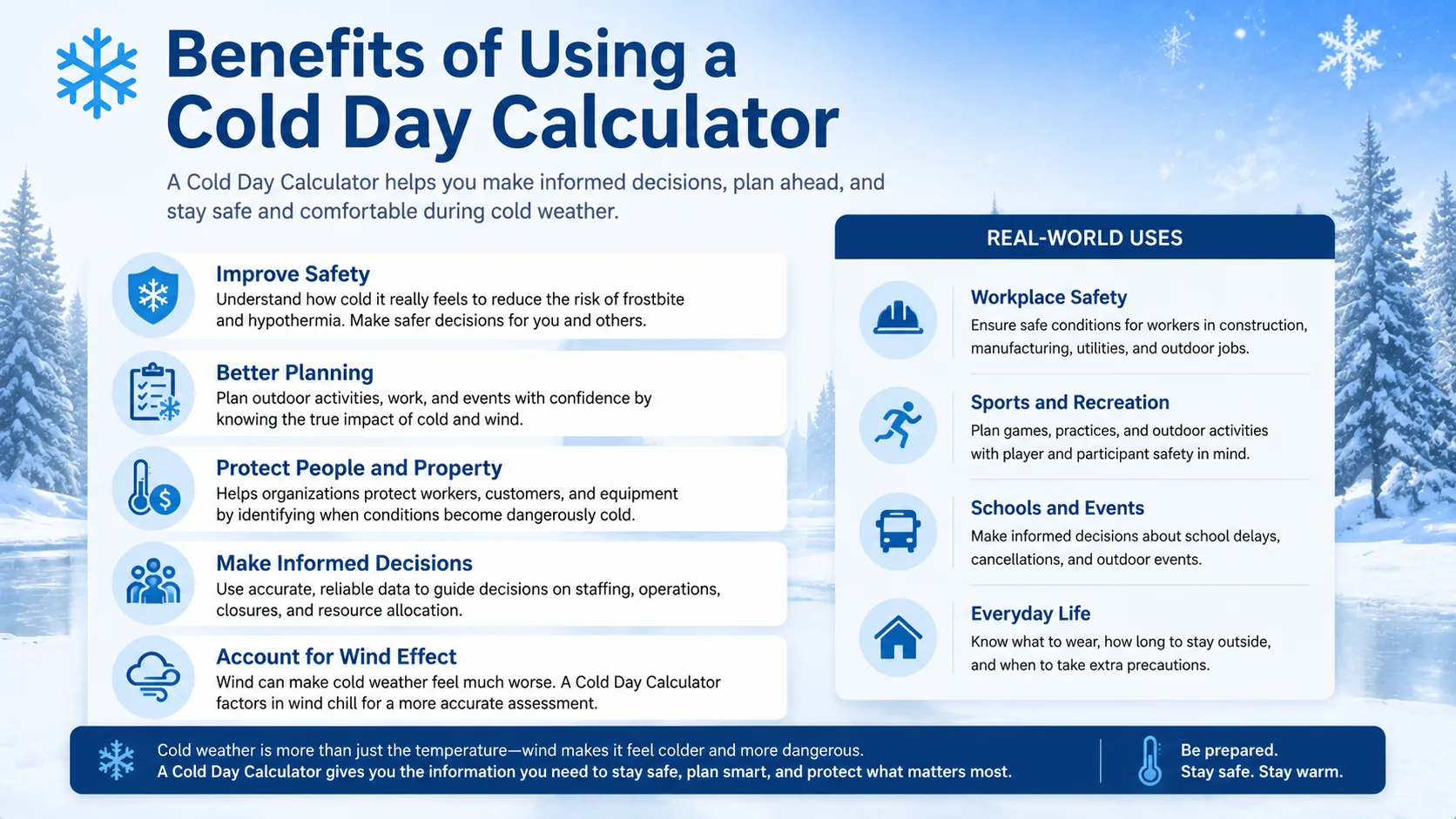
- Removes guesswork. You get an exact feels like number instead of relying on how the air subjectively seems through a window.
- Protects children. Bus stop waits and short walks to school are exactly where frostbite risk concentrates most heavily.
- Saves planning time. Decide on layers, delays, or indoor backup plans in seconds instead of scrolling multiple weather apps.
- Standardizes decisions. Everyone in a household, classroom, or work crew operates from the same shared number.
- Supports outdoor workers. Construction crews, delivery drivers, and coaches can time breaks around documented risk rather than assumptions.
- Builds long term awareness. Checking regularly teaches you to instinctively factor in wind, not just temperature, all winter long.
Common Mistakes to Avoid When Checking Cold Day Risk
- Using gust speed instead of sustained wind speed. Gusts last only seconds and will artificially inflate the danger reading.
- Ignoring wind entirely. Judging risk from air temperature alone consistently underestimates real exposure danger.
- Forgetting the formula's limits. Wind chill only applies at or below 50°F and above 3 mph of wind, so results outside that range are not meaningful.
- Assuming higher air temperature always means a safer day. As the Chicago versus Winnipeg example shows, strong wind can flip that assumption completely.
- Checking the forecast once the night before. Wind speed shifts quickly, so recheck closer to the actual time of exposure whenever possible.
Pro Tips for Staying Safe on Extreme Cold Days
- Layer with a wind resistant outer shell. Wind chill risk is driven mostly by wind penetrating fabric, so a windproof layer matters more than sheer thickness.
- Cover ears, cheeks, and hands first. These areas develop frostbite fastest due to reduced blood flow at the extremities.
- Recheck wind chill within an hour of actual exposure time. Do not rely solely on the previous night's forecast for a morning decision.
- Keep exposure under the frostbite time shown for your current wind chill range. Use the chart above as a hard ceiling, not a rough guideline.
- Have an indoor backup plan ready. Set a personal cutoff, such as 0°F wind chill, where you automatically default to waiting inside.
Conclusion
A cold day calculator turns a vague feeling of "it's really cold out there" into a precise, science backed number you can actually plan around. By combining air temperature with wind speed through the official NWS wind chill formula, you get a far more accurate picture of real world risk than the thermometer alone can offer.
Whether you are deciding if your kids should wait outside for the bus, adjusting an outdoor workout, or setting a workplace safety policy, run your numbers through a cold day calculator before you decide. The math takes seconds, and the payoff is fewer surprises and safer mornings all winter long.
Also Checkout :