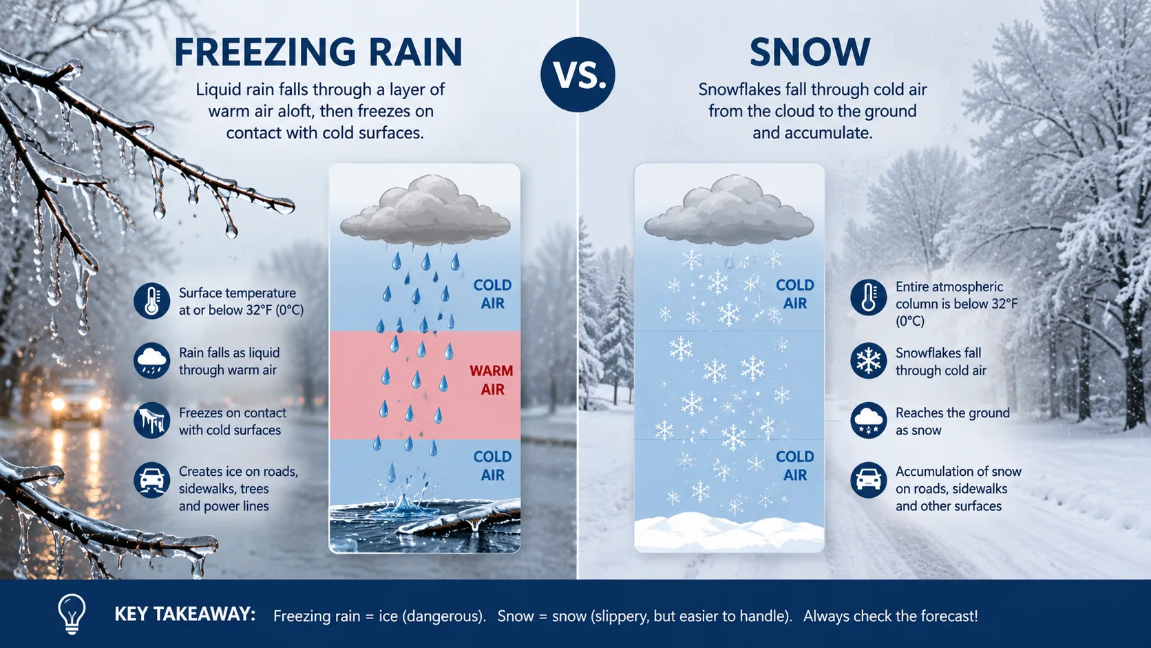
Freezing rain and snow are both cold-weather precipitation, but they form in different ways and behave very differently once they hit the ground. Snow forms when moisture freezes into ice crystals high in the atmosphere and stays frozen all the way down. Freezing rain forms when snow melts into liquid rain in a warm air layer, then refreezes the instant it touches a cold surface below 32°F. That single difference is why freezing rain creates dangerous ice, while snow just piles up.
If you are trying to figure out what tomorrow's storm will actually bring, you can run the numbers yourself with our snow day calculator, which factors in temperature layers, timing, and local school closure patterns.
What Is Freezing Rain vs Snow?
Snow is frozen precipitation that never melts on the way down, while freezing rain is precipitation that melts into liquid rain and then refreezes only after landing. Both start as snowflakes near the top of a storm cloud, but what happens to those flakes as they fall through the air below the cloud decides which one you actually see outside your window.
Meteorologists at the National Weather Service classify winter precipitation by tracking the vertical temperature profile of the atmosphere, not just the ground-level reading. That is the single biggest reason a forecast can call for freezing rain in one town and snow in a town twenty miles away, even when both places show the same temperature on a thermometer at ground level.
How Does Snow Form?
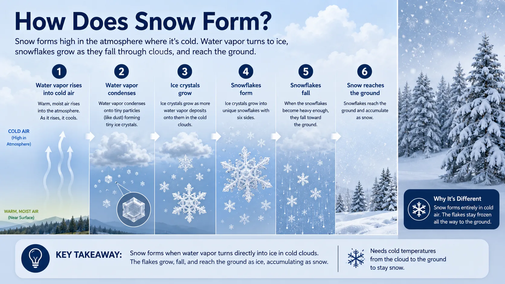
Snow forms when the entire air column from the cloud to the ground stays at or below freezing. Water vapor freezes directly into ice crystals inside the cloud, and those crystals clump together into snowflakes as they fall. Because the air never warms above 32°F at any point, the flakes reach the ground still frozen and pile up as snow.
The shape and texture of snow depends on a few factors:
- Air temperature near the surface, which affects whether snow is powdery or wet and heavy
- Humidity levels in the cloud, which shape how large the ice crystals grow
- Wind speed, which can pack snow down or cause drifting
Snow crystals actually start as tiny specks of dust or pollen floating high in a cloud. Water vapor collects on that speck and freezes in layers, growing into the six-sided shapes most people picture when they think of a snowflake. As the flake gets heavier, gravity pulls it down through the cloud and toward the ground.
Colder air holds less moisture than warmer air, which is part of why the driest, fluffiest snow tends to fall during the coldest outbreaks. Warmer snow, closer to 32°F but still below it, tends to be heavier and wetter because the flakes partially stick together on the way down. This "heavy wet snow" is more likely to snap branches and cause power outages than the light, powdery snow typical of a deep freeze.
You can plug your local numbers into our calculator directory to see how snowfall totals and timing typically translate into school closures in your area.
How Does Freezing Rain Form?
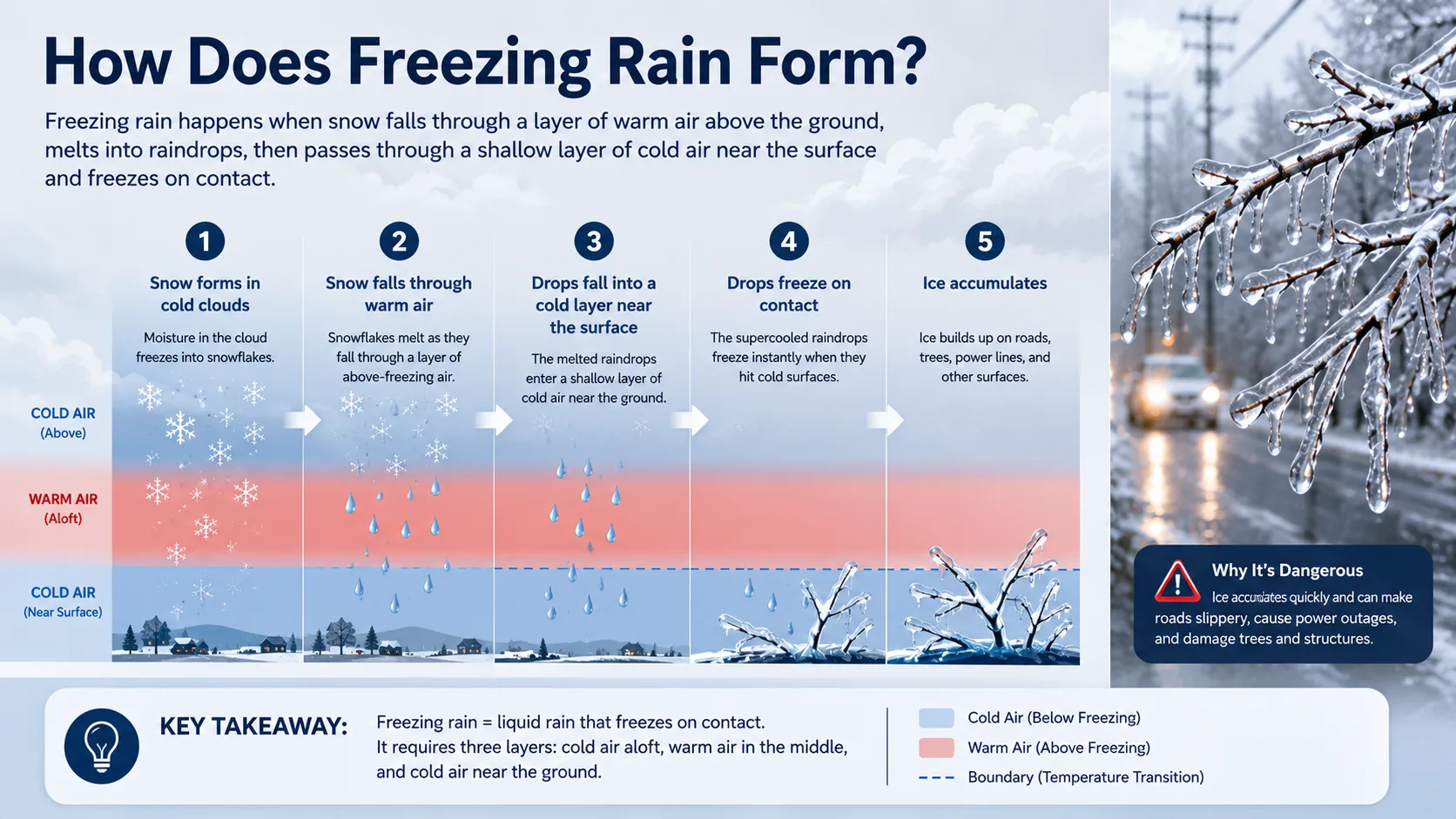
Freezing rain forms when falling snow passes through a layer of warm air thick enough to melt it into rain, then falls through a thin layer of below-freezing air near the ground before landing on a surface that is also below freezing. Because the cold layer near the ground is too shallow for the raindrops to refreeze mid-air, they stay liquid until the moment they hit a cold road, tree branch, or power line, where they instantly freeze into a shell of clear ice.
This is different from sleet, which forms when that near-ground cold layer is thick enough that the raindrops refreeze into small ice pellets before they ever reach the ground. Sleet bounces. Freezing rain does not, it spreads into a smooth, often invisible glaze.
According to general guidance from NOAA's National Weather Service, even a quarter inch of ice accumulation from freezing rain can snap tree limbs and bring down power lines, while a full inch of ice can cause widespread structural damage. That single fact explains why freezing rain advisories are treated as seriously as major snowstorms, even when the precipitation amount sounds small.
What makes freezing rain especially tricky to forecast is how narrow the temperature window really is. A shift of just one or two degrees in that warm layer aloft, or in the depth of the cold layer near the ground, can swing the outcome from freezing rain to sleet to plain snow. This is why winter storm forecasts sometimes change hour by hour as new data comes in, and why the National Weather Service often issues separate advisories for ice versus snow within the same storm system.
Freezing rain also tends to build up unevenly. Power lines, tree branches, and car antennas ice over faster than open pavement because thin objects lose heat quickly and reach freezing temperatures sooner. That is part of why you can sometimes see ice coating on a mailbox or fence before the road itself becomes slick, giving an early visual warning sign if you know what to look for.
The Science: Temperature Layers Explained
The type of winter precipitation you get comes down to a simple vertical temperature profile check, not the temperature at ground level alone. Forecasters look at the entire column of air from the cloud down to the surface. Here is how that column typically breaks down for each precipitation type:
| Precipitation Type | Upper Cloud Layer | Mid-Air Layer | Surface Layer | Typical Ground Result |
|---|---|---|---|---|
| Snow | Below 32°F | Below 32°F | Below 32°F | Frozen flakes accumulate |
| Freezing Rain | Below 32°F | Above 32°F (deep warm layer) | Below 32°F (thin cold layer) | Clear ice glaze on contact |
| Sleet | Below 32°F | Above 32°F (thin warm layer) | Below 32°F (thick cold layer) | Small bouncing ice pellets |
| Rain | Below 32°F | Above 32°F | Above 32°F | Liquid rain, no freezing |
Notice that snow and freezing rain can both start from the exact same cloud. The only difference is what those flakes pass through on the way down, and what the surface temperature is when they land.
Freezing Rain vs Snow: Key Differences
Here is a side-by-side breakdown of how these two winter weather events compare in practice:
| Factor | Snow | Freezing Rain |
|---|---|---|
| State on impact | Solid, already frozen | Liquid, freezes on contact |
| Road surface result | Loose or packed snow, usually visible | Clear, often invisible glaze ice |
| Driving danger level | Reduced traction, generally manageable with care | Extremely high, roads can look wet but be solid ice |
| Power line risk | Low, unless very heavy wet snow | High, ice weight snaps lines and limbs |
| Typical school response | Closure based on accumulation depth | Closure based on ice thickness, often even at low amounts |
| Cleanup method | Plowing and shoveling | Salting, sanding, and waiting for a thaw |
Want to see how these factors play out where you live? Our state-by-state predictions page tracks regional patterns so you can compare how your local district typically responds to each type of storm.
Step-by-Step: How to Tell What You'll Get
You do not need a meteorology degree to make a solid guess about tomorrow's storm. Follow these steps:
- Check the current surface temperature. If it is above 32°F, you are likely looking at plain rain unless a cold front is expected to move in fast.
- Look at the forecast temperature trend, not just today's number. A forecast that shows temperatures hovering right around 32°F for several hours is the classic setup for freezing rain.
- Check whether the forecast mentions a warm layer aloft. Many weather apps and the National Weather Service forecast discussion will note a "warm nose" in the atmosphere. If present, expect freezing rain or sleet instead of snow.
- Watch the timing of the coldest air. If the ground is well below freezing before precipitation arrives, snow is more likely even if temperatures rise slightly during the event.
- Run your numbers through a calculator. Enter your local forecast details into our main snow day calculator to get a quick read on which precipitation type and closure odds apply to your area.
Real-World Examples With Numbers
Example 1: The Classic Snow Setup. Ground temperature at 22°F, with air temperatures below freezing all the way up through the cloud layer at 18,000 feet. Result: 6 inches of dry, powdery snow over 8 hours. Roads are slick but plowable, and most districts issue a snow day based on total accumulation.
Example 2: The Classic Freezing Rain Setup. Ground temperature at 30°F, but a warm layer between 3,000 and 6,000 feet sits at 38°F. Rain falls through that warm layer as liquid, then hits the 30°F ground and freezes instantly. Result: just 0.3 inches of ice accumulation, but roads become undrivable and thousands lose power. Many districts close schools even though the "amount" of precipitation sounds small on paper.
Example 3: The Mixed Bag. Temperatures start at 34°F with rain, drop to 30°F by midnight as a cold front arrives, and end as light snow by morning. This produces a messy sequence: rain, then a glaze of ice as temperatures cross freezing, then a dusting of snow on top of the ice. This mixed scenario is often the most dangerous because the ice layer is hidden under a thin coat of snow.
Why This Matters: Benefits and Use Cases
Knowing the difference between freezing rain and snow is not just trivia. It changes real decisions:
- Parents can better judge whether a school closure is likely, since districts treat even light ice accumulation as more dangerous than several inches of snow
- Drivers can decide whether it is safe to head out, since freezing rain often looks like wet pavement while actually being solid ice
- Homeowners can prepare for power outages ahead of ice events, since ice adds far more weight to trees and lines than an equivalent depth of snow
- Event planners and commuters can time their schedules around the window when a warm layer aloft is expected to disappear
If your area also deals with sudden temperature swings, it is worth checking our wind chill calculator as well, since dangerously cold wind chill often accompanies the cold air mass that follows a freezing rain event.
Utility companies and emergency management agencies also rely on this same freezing rain versus snow distinction when deciding how to allocate crews before a storm. Ice events typically call for more line crews and tree removal teams to be staged in advance, while heavy snow events call for more plows and road crews. Understanding which type of storm is coming helps entire communities, not just individual households, prepare more effectively.
Common Mistakes and Pro Tips
Mistake 1: Assuming the ground temperature tells the whole story. A 30°F reading on your phone does not rule out rain if a warm layer sits above you. Always check the forecast discussion, not just today's high and low.
Mistake 2: Underestimating small ice totals. A quarter inch of ice sounds minor compared to six inches of snow, but it is often more disruptive. Never compare ice and snow totals on a one-to-one basis.
Mistake 3: Driving on roads that "look" wet. Freezing rain often creates a glassy, hard-to-see glaze that looks like a wet road until you lose traction. If temperatures are near freezing and the road looks unusually shiny, treat it as ice.
Pro Tip: Bridges and overpasses freeze before regular roads because cold air can circulate both above and below them. Assume they are icy first, even if the road leading up to them seems fine.
Pro Tip: If your event involves outdoor timing, such as a sports game or delayed start, our rain delay calculator can help you estimate how long a freezing rain window is likely to last before conditions clear.
Mistake 4: Assuming plowed roads mean clear roads. Plows are built to push loose snow, not to remove a bonded layer of ice. A road can look freshly plowed and still have a thin ice base underneath, especially in shaded areas or on bridges where sunlight cannot help melt the surface.
Pro Tip: Keep a small bag of sand or cat litter in your car during ice season. If you get stuck on a patch of freezing rain ice, pouring it under your tires can restore enough traction to get moving again without needing a tow.
Read More : Snow Day Estimator
Which Is More Dangerous: Freezing Rain or Snow?
Freezing rain is generally more dangerous than snow, even in smaller amounts, because it creates a layer of solid, often invisible ice rather than a loose, visible surface. Emergency management officials and local utility companies consistently point to ice storms, not blizzards, as the leading cause of large-scale power outages during winter weather. A heavy snowstorm can be exhausting to shovel and slow to drive through, but a moderate ice storm can shut down an entire region for days by taking down power infrastructure.
That said, heavy wet snow, especially several inches falling in a short window, carries its own serious risks, including roof collapses on flat or poorly maintained structures and an increased number of heart attacks from snow shoveling.
The safest approach is to treat both events with the same level of caution rather than ranking one as automatically worse. A light snow with strong wind can create whiteout conditions and dangerous drifting on highways, while a light glaze of freezing rain can shut down an entire commute in minutes. Checking the specific forecast details for your storm, rather than relying on general assumptions about snow versus ice, will always give you a more accurate picture of the actual risk.
Conclusion
Freezing rain and snow may start out as the same thing high in the clouds, but the path each one takes through the atmosphere decides whether you end up shoveling a driveway or chipping ice off your windshield. Snow stays frozen the whole way down. Freezing rain melts, then refreezes the instant it lands, which is exactly why it causes outsized damage even in small amounts.