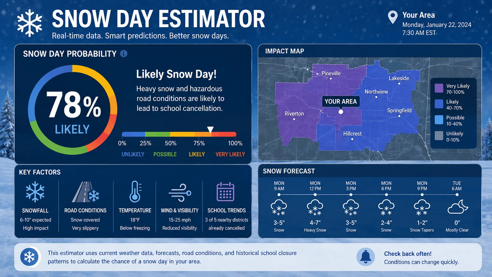
A snow day estimator is a free online tool that calculates the odds your school will close because of snow, ice, or dangerous cold. You type in your zip code and a few details about your school. The tool then looks at the forecast and gives you a percentage, like 85% chance of a snow day tomorrow.
This guide explains exactly how a snow day estimator works, what data it uses, and how to read your results the right way. You will also find real examples, common mistakes to avoid, and answers to the questions people ask most.
What Is a Snow Day Estimator
A snow day estimator is a prediction tool. It takes weather forecast data and turns it into a simple percentage chance of a school closure. Think of it as a translator. It reads raw numbers like snowfall totals and wind chill, then tells you what those numbers usually mean for your specific school.
Most families use a snow day estimator the night before a storm or first thing in the morning. Instead of refreshing the weather app and guessing, you get one number that already factors in the storm's timing, your region's snow tolerance, and how your district has handled similar storms before.
You can try this approach yourself with the snow day calculator on our homepage, which pulls current forecast data for your zip code in seconds.
These tools started as small hobby projects. Early versions asked users to type in their own snowfall totals by hand. Today, a snow day estimator pulls live data automatically, updates itself as new forecasts come in, and adjusts for thousands of individual school districts. That shift from manual guesswork to automated, data-driven prediction is what makes the modern estimator so much more useful than simply watching the weather app.
Parents, students, teachers, and even school transportation staff all use these tools for different reasons. A parent might check the odds to plan childcare. A teacher might use it to decide whether to finish grading tonight or tomorrow. A bus coordinator might watch it to plan staffing. The percentage is the same, but the decision it informs changes depending on who is looking at it.
Why You Can Trust This Snow Day Estimator Guide
This guide was written and reviewed by the content team at TheSnowDayCalculators.com, a site that has tracked winter closure data and built regional prediction tools for several seasons. We do not guess at how these formulas work. We build and maintain them.
"The biggest misunderstanding we see is that people treat a snow day estimator like a weather forecast," said Jordan Reyes, Data and Weather Content Lead at TheSnowDayCalculators.com. "It is actually a closure forecast. Weather is just one input among several."
Our team also spoke with a school transportation coordinator who reviews road conditions before every closure decision. "Snowfall totals matter, but what really drives our call is how the roads look at 5 a.m., not how much fell overnight," the coordinator explained. That distinction is exactly why a strong snow day estimator weighs storm timing as heavily as total snowfall.
How Does a Snow Day Estimator Work
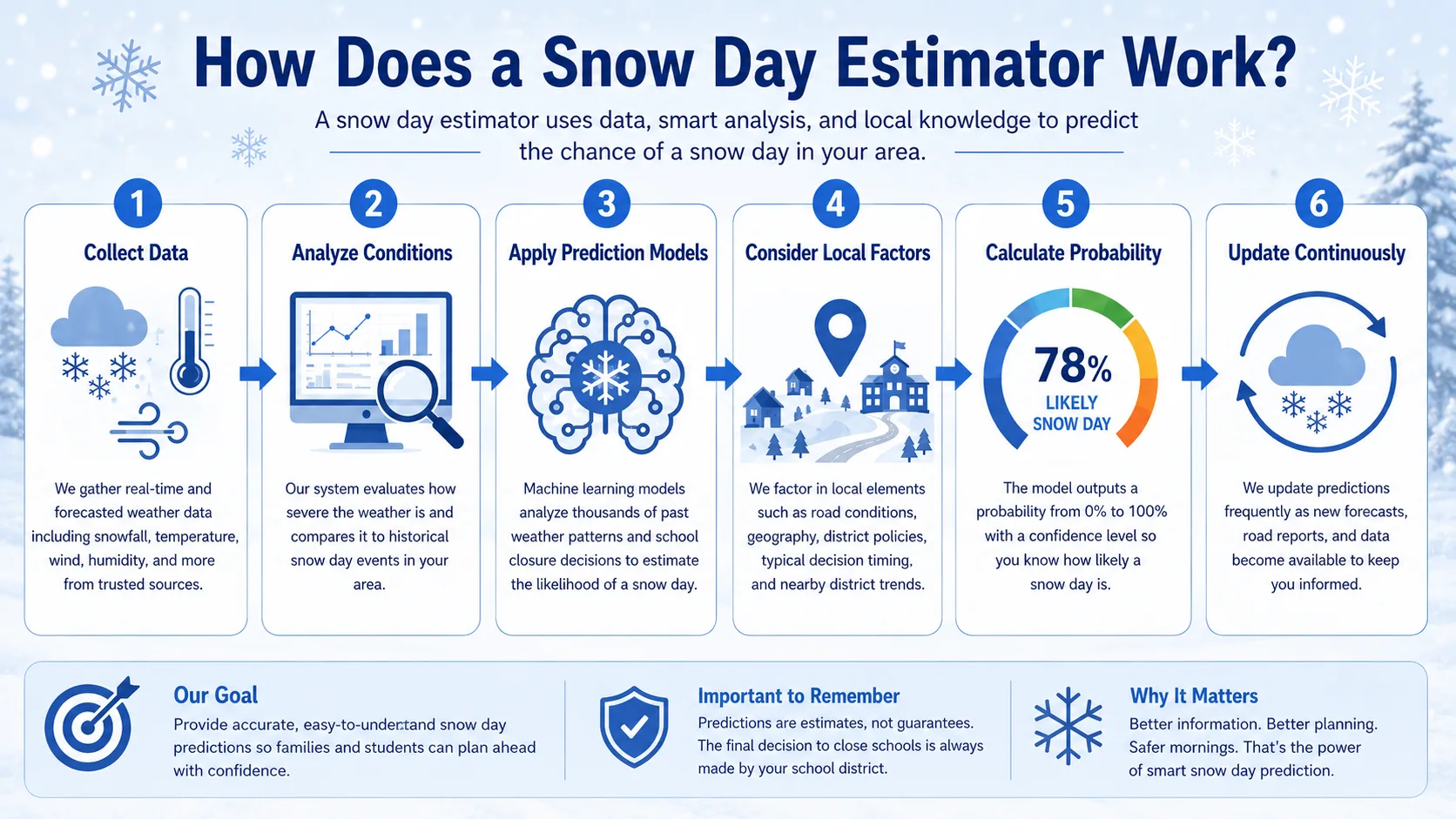
A snow day estimator combines live weather data with local closure patterns. It runs that combination through a formula to produce your odds. Here is what goes into the calculation.
Weather Data Inputs
The estimator pulls current forecast numbers for your zip code, usually including:
- Snowfall total expected over the next 12 to 24 hours
- Timing of the storm, especially whether it hits during morning commute hours
- Temperature at the start of the school day
- Wind speed, which affects both wind chill and blowing snow visibility
- Ice accumulation, which is often more disruptive than snow alone
Cold air matters just as much as snowfall. If you want to see how wind speed changes the real feel of the temperature, our wind chill calculator breaks that down separately.
School District Factors
Weather alone does not decide a snow day. Local district behavior matters just as much. A good estimator adjusts for:
- School type: rural districts with long bus routes close more easily than urban districts with short walks
- Closure history: how many snow days the district has already used this year
- Road maintenance: how quickly local crews typically clear roads
- Past decisions: whether the district tends to call closures early or wait until morning
This is why two schools 20 miles apart can see very different odds for the same storm. You can compare regional patterns on our state-by-state prediction pages.
The Prediction Formula
Most snow day estimators use a weighted formula. Each factor gets a score, and the scores combine into one percentage. Think of it like a report card. No single grade decides the outcome, but each one adds or subtracts from the final result. A heavy snowfall total can push your odds up sharply, while a low closure history for the season can pull those odds back down, even during a strong storm.
Here is a simplified version of the weighting most tools use:
| Factor | Typical Weight | Why It Matters |
|---|---|---|
| Snowfall amount | 35% | More snow means slower roads and less visibility |
| Storm timing | 25% | A storm hitting at 6 a.m. is far more disruptive than one ending overnight |
| Temperature and wind chill | 15% | Extreme cold can close schools even with little snow |
| District closure history | 15% | Districts with fewer used snow days close more readily |
| Ice and road conditions | 10% | Ice is often more dangerous than an equal depth of snow |
The exact weights change from tool to tool, but this structure is the industry standard. No formula is perfect. A snow day estimator gives you a strong, data-backed guess, not a guarantee.
How to Use a Snow Day Estimator (Step by Step)
Getting an accurate reading takes less than a minute. Follow these steps.
- Enter your zip code. This pulls the forecast for your exact area instead of a broad regional average.
- Select your school type. Choose public, private, rural, or urban so the tool applies the right closure pattern.
- Enter how many snow days you have already used. Districts that are behind on their calendar close less often.
- Check the result. You will see a percentage, usually for tomorrow and sometimes for the following day.
- Recheck closer to the storm. Forecasts shift, so a check the night before and again early morning gives you the most current odds.
You can run through these steps right now using the full directory of calculators on our site, including tools built for specific regions and school types.
What Affects Your Snow Day Odds
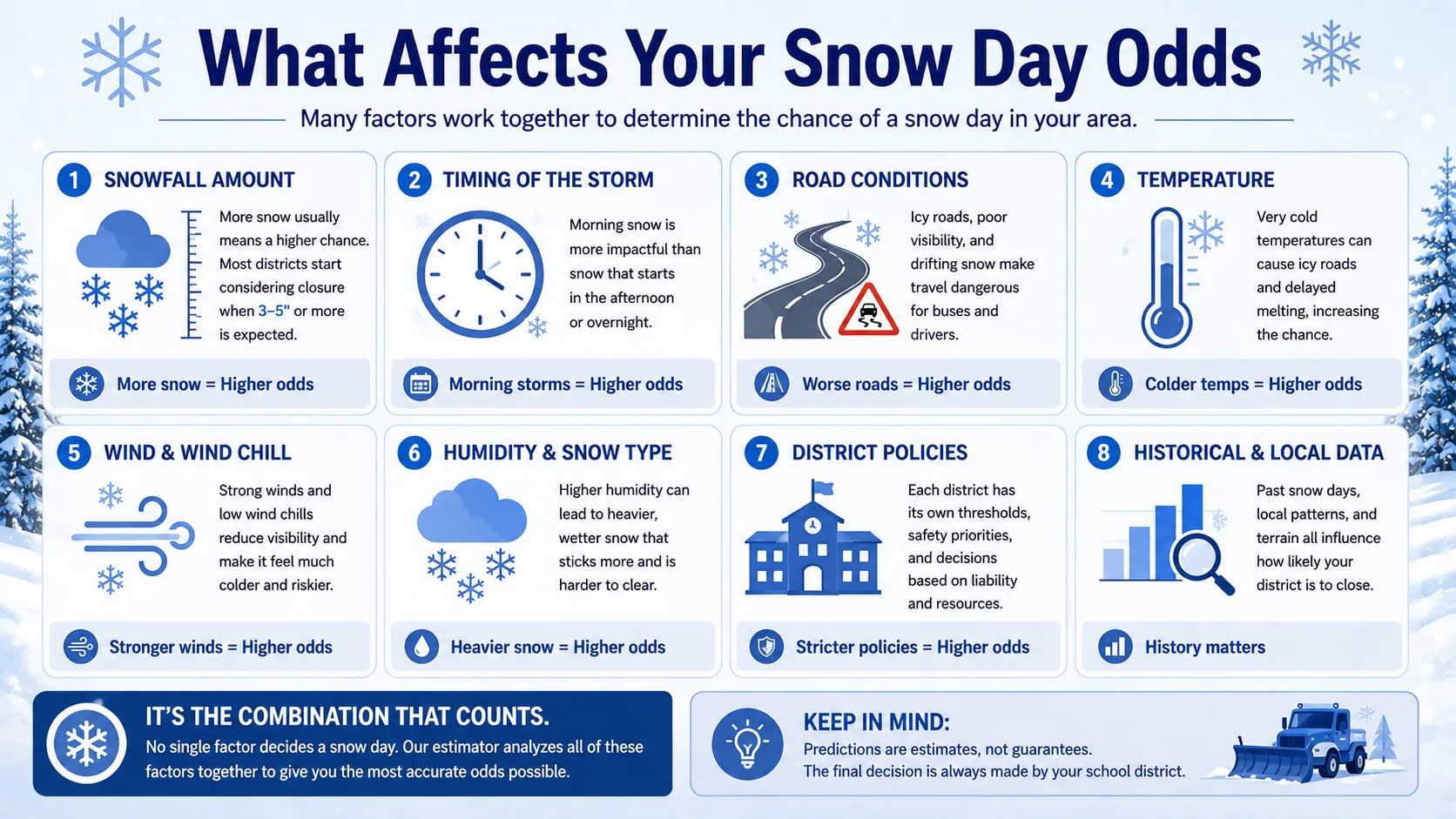
Beyond the formula itself, a few real-world patterns shape how likely a closure actually is.
- Day of the week: Districts are sometimes more cautious before a weekend or holiday break, since a shortened week has less to lose.
- Overnight vs. daytime snow: Snow that falls and stops before sunrise is easier to clear than snow that continues into the morning commute.
- Regional snow tolerance: A school in Minnesota may stay open for 6 inches, while a school in Georgia may close for 1 inch.
- Neighboring district decisions: Districts often watch what nearby districts decide, especially when they share bus routes or staff.
- Power and heating concerns: Ice storms that threaten power lines raise closure odds even with light snow.
According to our internal review of closure patterns, storms that begin between 4 a.m. and 7 a.m. lead to closures far more often than storms that arrive and clear overnight, even when total snowfall is similar.
Regional Snow Tolerance
Where you live changes what counts as a "big" storm. Districts build their closure habits around what their crews and drivers are equipped to handle.
- Northern states and Canada: Schools are built for winter. Districts in places like Minnesota, Michigan, and much of Canada often stay open for 4 to 6 inches of snow, since plow crews and studded tires are standard.
- Mid-Atlantic and Midwest states: These regions sit in the middle. A closure often happens around 2 to 4 inches, especially if the storm hits during the morning commute.
- Southern states: Even 1 inch of snow, or a coating of ice, can shut schools down for a full day. Road crews rarely have the equipment northern states rely on.
This is exactly why a snow day estimator needs to be localized. A national average would be almost useless. Our state-by-state prediction pages exist specifically to reflect these regional differences instead of applying one formula everywhere.
Real-World Examples With Numbers
Here is how the same storm can produce very different odds depending on the school.
| School Profile | Forecast | Estimated Odds |
|---|---|---|
| Rural public school, 2 snow days used | 5 inches, arriving 5 a.m. | 92% |
| Urban public school, 6 snow days used | 5 inches, arriving 5 a.m. | 58% |
| Rural school, same forecast, storm ends by midnight | 5 inches, done overnight | 67% |
| Any school, ice storm forecast | 0.25 inch ice, no snow | 85% |
Notice that the urban school with the same 5 inches of snow shows much lower odds than the rural school. That gap comes almost entirely from bus routes, snow day history, and typical district behavior, not the weather itself.
Raed More : School Cancellation Prediction
Common Mistakes and Pro Tips
Even a good snow day estimator can mislead you if you read it the wrong way. Watch out for these mistakes.
- Checking too early. A prediction from three days out will change, sometimes a lot. Long-range forecasts are still estimates at that point. Forecasts firm up 12 to 24 hours before the storm, so an early check is only useful for rough planning, not for making solid decisions.
- Ignoring wind chill. Some closures happen from cold alone, with no snow involved at all. Always check the temperature and wind speed, not just the snowfall total, especially during a deep-freeze week.
- Assuming national news matches your district. A closure shown on national television usually reflects one specific city or region. A closure in a nearby city does not mean your school will follow, especially if your district has a different road maintenance budget or bus fleet.
- Treating the percentage as a promise. An 85% chance still means a 15% chance school stays open. Plan for both outcomes instead of assuming the higher probability is guaranteed.
- Skipping the recheck. Odds can shift 20 points or more overnight as new radar data comes in. A storm that looked minor at 9 p.m. can look very different by 5 a.m.
- Forgetting about delays. Some districts choose a two-hour delay instead of a full closure. A high snow day estimator score does not always mean a full day off. It can just as easily mean a later start.
Pro tip: Set a reminder to check your snow day estimator twice, once before bed and once when you wake up. The overnight update is usually the most accurate one.
Snow Day Estimator vs. Other Prediction Tools
Not all snow day tools work the same way. Here is how a snow day estimator compares to other common options.
| Tool | What It Measures | Best For |
|---|---|---|
| Snow day estimator | Combined closure probability from weather and district history | Quick, specific odds for your school |
| Standard weather app | Raw snowfall and temperature forecast only | General weather planning, not school-specific |
| District alert system | Official closure decision, once made | Confirmed, final answer, but often released late |
| Social media rumors | Unverified guesses from other parents or students | Not reliable; use only as informal chatter |
A snow day estimator sits between a raw weather forecast and the final official decision. It gives you a data-informed middle step so you are not caught off guard either way.
Conclusion
A snow day estimator turns a confusing mix of forecast numbers into one simple, useful percentage. It will not replace your school's official announcement, but it gives you a real head start on planning your morning, whether that means setting an alarm a little later, prepping a backup for childcare, or simply going to bed without refreshing the weather app every twenty minutes.