Every winter, millions of parents, students, and teachers ask the same urgent question the moment flurries appear on the forecast: how much snow does it take to cancel school? The answer is far more nuanced than a single number it depends on your state, your region's infrastructure, local road conditions, wind chill, and even the personality of your school superintendent.
How much snow to cancel school varies wildly across the United States. In Louisiana, a light dusting can shut down an entire district. In Buffalo, New York, schools routinely open after 8 or 9 inches of overnight snow. Understanding these regional differences helps parents plan childcare, allows students to manage expectations, and gives educators a clearer picture of when a closure call is likely.
This comprehensive, state-by-state guide breaks down the snow cancellation thresholds for every region of the country, explains the key factors administrators consider, and provides practical tips for staying ahead of closures. Whether you're in the Snow Belt or the Sun Belt, you'll find exactly what you need here.
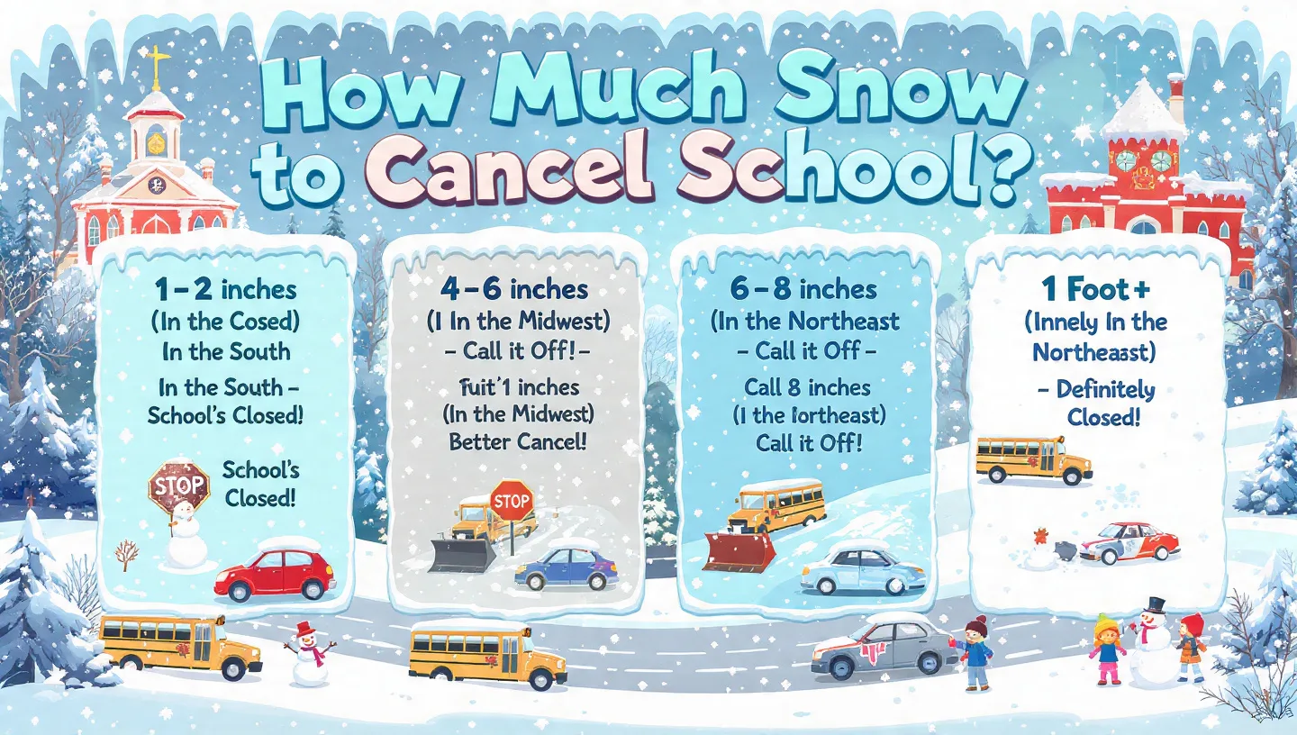
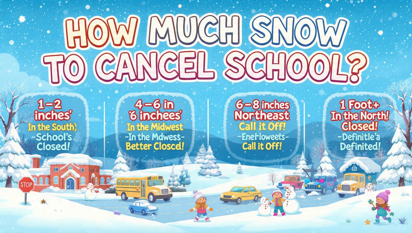
Nationally, 5 to 6 inches of snow is the average threshold triggering school closures. However, southern states may cancel school at a trace of snow, while northern and mountain states often require 10 to 12 inches or more before calling a snow day.
The National Snow Day Picture: Why One Number Never Fits All
There is no federal law or national standard that dictates when schools must close due to snow. The decision is entirely local made by individual school districts, superintendents, and transportation directors. As a result, school snow cancellation thresholds differ not just state by state, but sometimes district by district within the same county.
According to data analysis by Snow Day Calculator a platform that aggregates weather data and historical school closure records over 9 inches of snow separate the most and least snow-resilient counties in the United States. That's a massive gap driven primarily by infrastructure readiness and historical experience with winter weather.
"Predicting snow days is about a lot more than weather. Sometimes it comes down to the leniency of the school administrator calling the shots and a little bit of luck."
Snow Day Calculator, analysis of school district closure patterns
Why Southern States Close at Trace Amounts
States like Georgia, Louisiana, Mississippi, and Alabama don't close schools because their residents are soft they close because their infrastructure simply isn't designed for snow. These states have minimal road salt stockpiles, few snowplows, and drivers with little to no experience navigating icy roads. A half-inch of snow on untreated pavement in Atlanta is genuinely more dangerous than 12 inches on a pre-salted highway in Cleveland.
As one community forum noted, cities like New Orleans don't sell ice scrapers or tire chains at local stores and almost no vehicles have winter tires. When snow is a once-in-a-decade event, there's simply no reason to build an expensive snow-removal infrastructure.
Why Northern States Stay Open Through Major Storms
In contrast, cities like Chicago, Minneapolis, and Buffalo have invested heavily in road maintenance fleets. Large urban districts in northern states maintain fleets of plows and salt trucks that can clear major roadways before the morning commute even begins. Drivers in these regions are accustomed to winter conditions, and school buses are equipped for icy roads.
Snow Cancellation Thresholds by Region at a Glance
Below is a quick-reference overview of typical snow thresholds by region, before we dive into individual state details.
Southeast (GA, NC, SC, TN, VA)
Lowest tolerance. Icy roads are the primary risk. Limited snow equipment.
Deep South (AL, MS, LA, TX, FL)
Any snow or even the forecast of snow can trigger closures.
Northeast (NY, MA, CT, PA, NJ)
Well-equipped urban areas. Nor'easters bring faster closures due to wind.
Midwest (OH, MI, WI, MN, IL)
Lake-effect regions close sooner. Rural districts are more cautious.
Mountain West (CO, MT, WY, ND)
High tolerance. Wind chill and temperature often matter more than snow depth.
Pacific West (WA, OR, CA)
Mountain areas close earlier. Coastal regions react to freezing slush and ice.
Complete State-by-State Snow Cancellation Guide
The following table summarizes typical snow thresholds, key closure factors, and school snow day tolerance ratings for all major U.S. states. Note that these are general averages individual districts within each state may vary significantly.
| State | Avg. Snow Threshold | Key Factors | Tolerance |
|---|---|---|---|
| Alabama | Any snow / trace | No snow equipment; icy bridges | Very Low |
| Alaska | 12–24"+ | Extreme cold triggers; not snow depth | Very High |
| Arizona | 1–3" (northern); rare in Phoenix | Elevation-dependent; Flagstaff vs. Phoenix | Low–Mid |
| Arkansas | 1–2" | Ice storms more common than snow | Low |
| California | Varies widely by elevation | Mountain districts close at 6–12"; coast rarely closes | Varies |
| Colorado | 10–12" (Front Range); more in mountains | Temperature type (wet vs. dry snow); wind | Very High |
| Connecticut | 6–8" | Nor'easters; road ice; wind chill | High |
| Delaware | 3–5" | Ice risk; coastal storms | Medium |
| Florida | Any snow / flurries | Extremely rare; any snow = closure | Extremely Low |
| Georgia | 1–2" | Icy overpasses; lack of salt trucks | Very Low |
| Idaho | 8–12" | Mountain terrain; rural bus routes | High |
| Illinois | 6–8" (Chicago); 4–6" (rural) | Lake-effect near Chicago; wind chill | High |
| Indiana | 4–7" | Ice layer under snow; rural roads | Medium–High |
| Iowa | 6–10" | Wind chill; blowing snow visibility | High |
| Kansas | 5–8" | Wind and blowing snow; flat terrain | Medium |
| Kentucky | 2–4" | Hilly terrain; freezing rain common | Low–Medium |
| Louisiana | Any snow / trace | No salt; no plows; unfamiliar drivers | Extremely Low |
| Maine | 8–12" | Extremely prepared; rural distance matters | Very High |
| Maryland | 3–5" | Hilly terrain; icy bridges; DC-area traffic | Medium |
| Massachusetts | 6–10" | Nor'easters; coastal flooding risk | High |
| Michigan | 6–10" (wind chill often triggers first) | Wind chill below -15°F; lake-effect bands | High |
| Minnesota | 8–12" | -20°F wind chill threshold common | Very High |
| Mississippi | Any snow / trace | No infrastructure; rare event | Extremely Low |
| Missouri | 2–4" (south); 4–6" (north) | Ice storms; freezing rain precedes snow | Low–Medium |
| Montana | 12–18" | Wind chill; blizzard conditions; temperature | Very High |
| Nebraska | 6–10" | Blowing snow; wind advisory threshold | High |
| Nevada | 6–10" (Reno/Tahoe); rare in Las Vegas | Elevation; mountain roads | Varies |
| New Hampshire | 8–12" | Winding rural roads; cold temps | High |
| New Jersey | 4–7" | Dense traffic; Nor'easters | Medium |
| New Mexico | 4–8" (north); 1–2" (south) | Elevation gradient; dry vs. wet snow | Medium |
| New York | 8–12" (NYC); up to 10" in Erie Co. | Lake-effect in Buffalo; NYC plowing capacity | High |
| North Carolina | 1–3" | Large district geography; ice-first events | Very Low |
| North Dakota | 12–18" | Temperature and wind chill override snow depth | Very High |
| Ohio | 4–7" (north); 2–4" (south) | Ice under snow; lake-effect in NE Ohio | Medium |
| Oklahoma | 2–4" | Ice storm state; freezing rain is primary trigger | Low |
| Oregon | 4–6" | Wet snow turns to ice; steep roads | Medium |
| Pennsylvania | 4–7" | Mountainous terrain; rural bus routes | Medium |
| Rhode Island | 5–7" | Coastal storms; compact geography | Medium |
| South Carolina | Any snow / 1" | Rare snow; no removal equipment | Very Low |
| South Dakota | 10–14" | Blizzard wind; temperature threshold | Very High |
| Tennessee | 1–3" | Hilly terrain; ice; limited plows | Low |
| Texas | Any snow / trace (most areas) | Winter Storm Uri impact; no infrastructure | Very Low |
| Utah | 8–12" | Mountain passes; school bus safety | High |
| Vermont | 12–18" | Very high tolerance; well-prepared crews | Very High |
| Virginia | 2–5" | Hilly terrain; ice; large district geography | Low–Medium |
| Washington | 4–6" | Wet snow + freeze cycle; steep roads in Seattle | Medium |
| West Virginia | 3–6" | Extremely hilly; winding rural roads | Medium |
| Wisconsin | 6–10" | Lake-effect near Lake Michigan; wind chill | High |
| Wyoming | 12–18" | Blizzard wind; highway closures | Very High |
Source: Compiled from NOAA data, Snow Day Calculator research, and regional school district records. National average: 5–6 inches.
Beyond Snow Depth: The 7 Factors That Actually Decide School Closures
Snow accumulation is just one variable in a complex equation. School administrators actually weigh at least seven distinct factors when making a closure call and understanding these helps you predict snow days more accurately than simply watching the snow depth.
1. Wind Chill and Extreme Cold
In the Midwest and Great Plains, wind chill often triggers school closures before snow accumulation does. According to Tina Kerr, Executive Director of the Michigan Association of Superintendents and Administrators, many Michigan schools have policies to close when wind chill drops below a certain threshold commonly -15°F to -20°F because students waiting at bus stops face genuine risk of frostbite.
Minnesota, North Dakota, and Wisconsin frequently cancel school on days with little or no snowfall simply because temperatures plunge to dangerous extremes.
2. Ice Accumulation Often More Dangerous Than Snow
A thin glaze of ice is frequently more disruptive than a foot of fluffy snow. Even 0.1 inches of ice accumulation can make roads impossible for school buses to navigate safely, particularly on hills, bridges, and overpasses. In Southern Ohio and Kentucky, ice storms routinely cause closures at snow totals that would be laughed off in Chicago.
Many districts in the Mid-South experience freezing rain before snow a thin ice layer under the snowpack that dramatically increases road danger. This is why areas like Cincinnati and Louisville can close at 2–3 inches, while nearby Chicago stays open at 6–7 inches.
3. Storm Timing: Morning Snow Is the Biggest Threat
When a snowstorm hits overnight and ends by 3 AM, plows have several hours to clear roads before buses depart. But a storm that begins at 5 AM just as transportation directors are doing their pre-dawn route checks creates maximum disruption. The timing of snowfall relative to the morning commute window (6–8 AM) is often the single most decisive factor in whether a district closes.
4. Bus Route Safety Checks
Most districts have transportation directors who physically drive bus routes between 3:00 AM and 5:30 AM on potential snow days to assess actual road conditions. This real-world check often overrides even the weather forecast. A bus that can't safely navigate a specific rural road with steep grades may trigger a district-wide closure even if the overall snowfall was modest.
5. Rural vs. Urban Geography
Urban districts with compact student populations and heavily plowed arterial roads can often remain open when surrounding rural districts close. Rural districts face longer bus routes on secondary roads that are plowed less frequently and later. Rural districts almost always close at lower snowfall totals than urban districts in the same region.
6. Storm Type: Nor'easters, Lake-Effect, and More
Not all snow is created equal. Storm type fundamentally changes the closure calculus:
- Nor'easters : Slow-building but long-lasting storms along the East Coast. The extended duration and high winds accelerate closures even at moderate accumulations.
- Lake-Effect Snow : Narrow, intense bands of snow that can drop several inches per hour in specific areas. Buffalo and Cleveland are infamous for lake-effect events. These bands are unpredictable and can bury a district while a neighboring town stays dry.
- Short Snowbursts : Quick, heavy bursts that occur during the morning commute. Even 2–3 inches during the 6–8 AM window can create dangerous whiteout conditions.
- Wet Snow : Heavy, wet snow sticks to tree branches and power lines, causing outages. Wet snow is also heavier on roads, making driving harder but it's often easier to plow than dry powder.
7. Forecast Reliability and Decision Timing
Administrators rarely have perfect information. When weather models disagree or forecast uncertainty is high, many superintendents opt for early announcement of closures the previous evening. When borderline conditions are anticipated, most districts wait until 4:30–6:00 AM to make the final call after reviewing actual conditions which is why the snow day announcement often comes just as you're waking up.
Inside the Decision: How School Administrators Call a Snow Day
The process is more structured than most parents realize. Here's a typical sequence followed by most U.S. school districts:
- 72–48 Hours Before: Weather monitoring begins. Administrators track forecasts from the National Weather Service, private weather services, and local meteorologists.
- 24 Hours Before: Consultation with the district transportation director and local highway/emergency management departments begins. Neighboring districts are contacted to discuss potential coordination.
- Evening Before (If Forecast Is Severe): In cases of obvious, forecast-certain storms, some superintendents announce closures the night before to help families arrange childcare.
- 3:00–5:00 AM Day-Of: Transportation directors physically drive key bus routes to assess actual conditions. School maintenance staff check building heating and parking lots.
- 5:00–6:30 AM: The superintendent (or designee) makes the final call. Notifications go out via automated phone systems, school websites, local TV/radio, and apps like School Messenger or ParentSquare.
"It's hard to pinpoint an actual temperature because they have to look at so many factors. A negative 15 or 20-degree wind chill is a common cutoff point for many Michigan schools."
Tina Kerr, Executive Director, Michigan Association of Superintendents & Administrators
Snow Days Are Changing: Remote Learning and Virtual Snow Days
The COVID-19 pandemic permanently changed how American schools handle weather closures. By establishing robust remote learning infrastructure in 2020–2021, many districts gained the ability to conduct "virtual snow days" maintaining instruction online even when the physical building is closed.
This creates an important distinction that didn't exist a decade ago: a "school building closure" is no longer the same as a "learning cancellation." Many districts now automatically transition to online instruction during weather events, meaning students still attend class just from their couch.
State Minimum Day Requirements and Snow Day Limits
One critical factor limiting how many snow days a district can call is state-mandated minimum instructional day requirements. Most states require between 175 and 180 school days per academic year. Districts must account for potential weather closures:
- Most districts build in 3–5 "built-in" snow days to their calendar. If unused, these often become early release days or additional holiday breaks in spring.
- Michigan, for example, allows schools to cancel up to 6 days for events outside their control (weather, health emergencies), with an option to request a waiver for 3 additional days from the state Department of Education.
- When snow day allotments are exhausted, many districts make up days at the end of the school year extending the calendar into June.
- States like Texas have occasionally issued waivers allowing schools to skip makeup days after major weather events, as occurred following severe winter storms.
Private Schools vs. Public Schools: Different Rules Apply
One often-overlooked factor in school closure decisions is the public vs. private school divide. Public schools are mandated by state law to meet minimum instructional day requirements, making administrators more reluctant to burn through snow days early in the year. Private schools, by contrast, operate under more flexible guidelines and can cancel school with greater freedom.
As a result, private schools in the same neighborhood often close before nearby public schools during borderline winter weather events. Rural public school districts also tend to close earlier than urban ones, because their students travel longer distances on less-maintained roads.
Read More : Snow Day Survival Guide for Parents
Practical Tips: How to Know If School Will Be Cancelled Tomorrow
Use a Snow Day Calculator
Tools like Snow Day Calculator (snowdaycalculator.com) combine real-time National Weather Service data with historical school district closure patterns to estimate the probability of a snow day. These calculators factor in your ZIP code, school type (public/private), temperature, wind chill, and accumulation forecasts. They typically achieve 75–85% accuracy for short-term predictions.
For the most accurate results, check the calculator the evening before a potential snow event, then again at 5:00–5:30 AM when most districts finalize their decisions.
Watch for These Key Indicators
- Morning snowfall: Snow timed between midnight and 6 AM dramatically increases closure odds.
- Ice in the forecast: A freezing rain or ice storm advisory almost always triggers closure at lower snow totals.
- Neighboring districts closing: If 2–3 neighboring districts announce closures the night before, yours likely will too.
- Wind chill advisories: In northern states, wind chill advisories below -15°F almost always mean closures regardless of snow totals.
- School announcements the night before: Districts facing obvious, severe storms often announce closures the previous evening, typically by 9–10 PM.
Sign Up for District Alerts
Most U.S. school districts use automated notification systems (School Messenger, ParentSquare, Blackboard Connect) that send closures via text, email, and app notification. Register your mobile number and preferred email with your district as early in the school year as possible to receive instant closure announcements.
Always have a backup childcare plan for borderline weather days when the forecast shows 2–6 inches. Closure calls often come as late as 6:00 AM far too late to arrange last-minute care. Snow days are far more manageable when you have a plan in place before the storm arrives.
Extreme Cases: The Most and Least Snow-Tolerant Places in America
The Most Snow-Tolerant: Alaska, Vermont, North Dakota, Montana
These four states represent the upper extreme of American snow tolerance. In parts of Vermont and Alaska, schools routinely operate in conditions that would paralyze most of the country. Alaska and North Dakota tend to use temperature and wind chill as their primary closure trigger rather than snowfall it can simply be too cold for children to wait safely at bus stops, regardless of how much snow falls.
In Fairbanks, Alaska, schools have been known to remain open at temperatures of -40°F, only closing when wind chill or mechanical concerns (frozen bus engines, frozen door locks) create genuine operational emergencies.
The Least Snow-Tolerant: Florida, Louisiana, Mississippi, South Carolina
At the other extreme, Florida, Louisiana, Mississippi, and South Carolina will cancel school for any measurable snowfall and in some cases, for merely the forecast of snow. This is entirely rational: these states have virtually no snow removal infrastructure, no salting programs for secondary roads, and a driving population with essentially zero experience navigating icy conditions.
In New Orleans, Louisiana, there are no ice scrapers sold in local stores. Most vehicles have summer or all-season tires. When snow does fall in these areas, even a quarter-inch can create genuinely dangerous road conditions that would be trivial in Minnesota.
"In northern areas of the United States, snow days occur when extreme winter weather overwhelms efforts to safely clear main roads often 1 to 2 feet. In areas less accustomed to snow, even small snowfalls of an inch or two may render roads unsafe."
Wikipedia, Weather-Related School Cancellation entry, citing NOAA and municipal records
Conclusion: Location Is Everything When It Comes to Snow Days
The question of how much snow cancels school has no single answer it's fundamentally a local question shaped by geography, infrastructure, history, and individual administrative judgment. What counts as a paralyzing blizzard in Atlanta is a light Tuesday dusting in Buffalo.
The national average of 5–6 inches provides a rough baseline, but the real determinants are your region's snow tolerance infrastructure, your district's bus route geography, storm timing, ice conditions, and wind chill. Understanding these factors rather than just watching the snowfall total gives you a far more accurate picture of whether schools will open tomorrow.
Use snow day calculators for data-driven estimates, sign up for district alerts for real-time updates, and always have a backup childcare plan ready when the forecast calls for winter weather. And remember: whether your threshold is a half-inch or a full foot, every snow day decision ultimately comes down to one question can we safely get kids to and from school today?