Lake effect snow is a heavy, highly localized snowfall that forms when cold air moves across the surface of a warmer, unfrozen lake, picks up moisture and heat, then dumps it as snow once it reaches land downwind. It is one of the fastest, most unpredictable ways a town can go from clear skies to whiteout conditions, and it is the reason places like Buffalo and Erie can see feet of snow while a town twenty miles away stays dry.
If you live anywhere near the Great Lakes, the Great Salt Lake, or the Finger Lakes, this guide breaks down exactly how lake effect snow works, why some towns get buried while their neighbors stay dry, and how you can check your own risk with our free snow day calculator before the next storm rolls in.
What Is Lake Effect Snow?
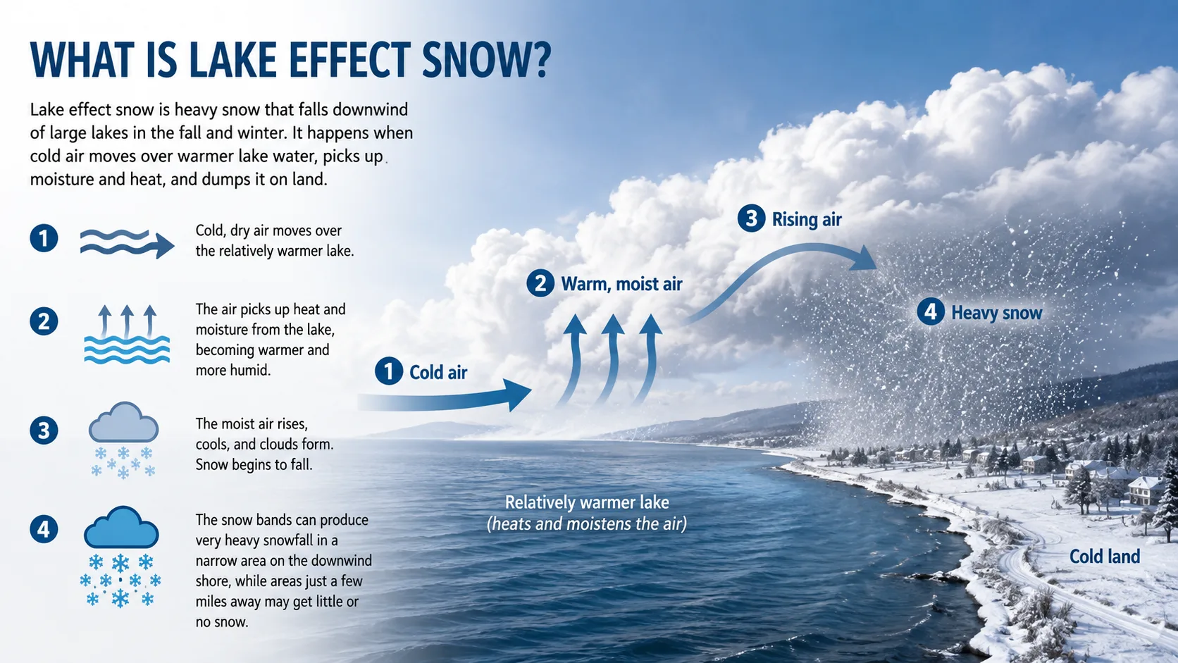
Lake effect snow forms when a mass of cold, dry air travels over the surface of a lake that is still much warmer than the air above it. As the cold air crosses the water, it absorbs heat and moisture, which makes the lowest layer of air unstable and causes it to rise.
Once that warm, moisture-loaded air rises high enough, it cools again and the water vapor condenses into clouds. When temperatures are cold enough, that condensed moisture falls as snow instead of rain, usually within about 25 miles of the shoreline, though it can travel up to 100 miles inland under the right wind pattern.
Unlike a typical winter storm, lake effect snow does not need a large low-pressure system to form. All it really needs is cold wind blowing over relatively warm water, which is why it can appear seemingly out of nowhere on an otherwise ordinary winter day.
How Does Lake Effect Snow Form?
The process happens in four stages, and understanding each one explains why the snow lands exactly where it does.
- Cold air moves over warm water. An Arctic air mass, often pulled down from Canada, crosses a lake whose surface water is still well above freezing.
- Heat and moisture transfer upward. Because water holds heat far longer than air, the lake warms the lowest layer of the atmosphere and evaporates water directly into it.
- The warm, moist air rises and cools. As this newly humid air lifts away from the lake surface, it cools quickly and the water vapor condenses into clouds.
- Snow falls in narrow bands downwind. Those clouds organize into long, narrow streamers, sometimes only a few miles wide, that dump intense snowfall on whatever land lies directly in their path.
Meteorologists sometimes describe the process like a sponge being wrung out. The air soaks up moisture while crossing open water, then squeezes it back out as snow the moment it hits colder land or rising terrain.
The Conditions Needed to Produce Lake Effect Snow
Not every lake, and not every cold snap, can trigger lake effect snow. Forecasters generally check for these specific conditions before issuing a lake effect snow warning.
| Factor | Typical Threshold | Why It Matters |
|---|---|---|
| Air-water temperature gap | 13°C+ colder at 5,000 ft than the lake surface | Bigger gaps drive more evaporation and stronger lift |
| Lake size (fetch) | Roughly 60+ miles across | Longer wind travel over water means more moisture pickup |
| Wind speed | 11 to 22 mph near the surface | Too calm limits moisture transfer; too fast disperses it |
| Wind direction | Aligned with the lake's longest axis | Determines which shoreline towns are directly hit |
| Wind shear | Minimal change with height | Keeps the moisture concentrated in one band instead of spreading out |
| Ice cover | Open, unfrozen water | A frozen lake surface cuts off the heat and moisture supply |
This is also why lake effect snow is heaviest in November and December. The lakes are still holding onto summer warmth while Arctic air masses have already arrived, creating the biggest possible temperature gap of the season.
How to Check Your Lake Effect Snow Risk
You do not need a meteorology degree to get a useful estimate of your own risk. Our full calculator directory includes tools built specifically for winter weather forecasting.
- Pick your location. Choose your city or zip code near a Great Lake, the Great Salt Lake, or another large body of water.
- Enter current air conditions. Add the local temperature, wind direction, and wind speed, or let the calculator pull live data automatically.
- Add the lake water temperature. This single number does more to predict snowfall totals than almost any other input.
- Read your snow risk estimate. The calculator combines all four factors into an estimated snowfall range and a snow day probability for your school or workplace.
For a broader look at how different regions are trending this winter, check our state-by-state snow predictions, which track lake effect risk alongside general winter storm forecasts.
Where Does Lake Effect Snow Happen?
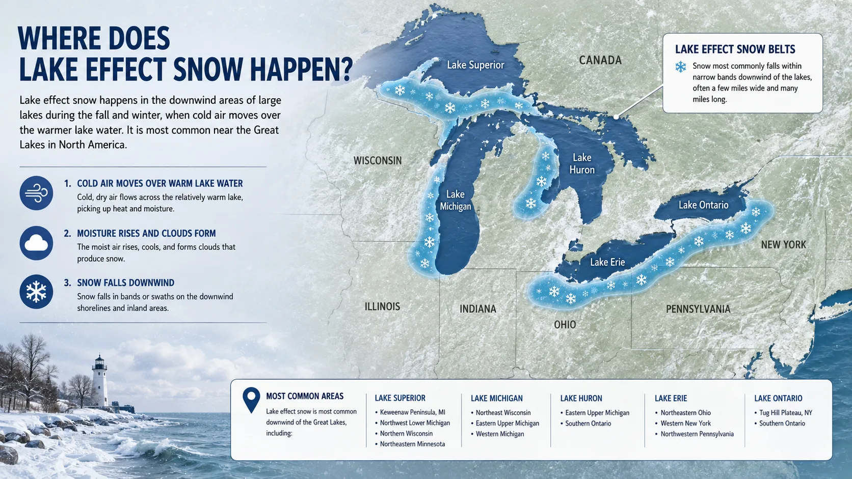
Lake effect snow is most famous around the Great Lakes, but it is not exclusive to them. Any sufficiently large, unfrozen lake paired with cold enough air can produce the same effect.
- The Great Lakes region: Western and central New York, northern Pennsylvania, Ohio, Michigan's Upper Peninsula, and parts of Ontario see the most frequent and heaviest events.
- The Tug Hill Plateau, New York: One of the snowiest inhabited areas in the eastern United States, thanks to both lake effect moisture and elevation.
- The Great Salt Lake, Utah: Produces smaller but noticeable lake effect snow bands east of Salt Lake City.
- The Finger Lakes, New York: Their long, narrow shape can funnel localized snow bands even though they are far smaller than the Great Lakes.
- Coastal Japan: Cold air crossing the Sea of Japan produces some of the heaviest lake and sea effect snowfall on Earth along Honshu and Hokkaido.
-
Real-World Examples With Numbers
Numbers make lake effect snow easier to grasp than any description of clouds and wind. Here are a few of the most striking examples on record.
- In November 2014, a lake effect band buried the Buffalo, New York area under nearly 7 feet of snow in roughly three days, collapsing roofs and stranding drivers on the New York State Thruway.
- In October 2006, an unusually early lake effect event dropped 22.6 inches of wet, heavy snow on Buffalo in under 24 hours, snapping tree branches that had not yet lost their leaves and knocking out power to nearly a million residents.
- A late 2022 event dumped more than 6 feet of snow on Buffalo's southern suburbs in about 48 hours, one of the most intense lake effect storms of the past decade.
- Michigan's Keweenaw Peninsula, which sits directly in the path of Lake Superior's moisture, commonly records more than 250 inches of snow per season, more than any other location east of the Mississippi River.
Read More : Snow Day Calculator Boston MALake Effect Snow vs. Regular Snow vs. Lake Effect Rain
Feature Lake Effect Snow Typical Winter Storm Snow Lake Effect Rain Trigger Cold air over warm lake water Large-scale low-pressure system Cold air over warm water, above-freezing temps Coverage area Narrow bands, a few miles wide Broad, often covers multiple states Narrow bands, same mechanism as snow Predictability Low; band location can shift fast Higher, tracked days in advance Low, same variability as lake effect snow Typical duration Hours to several days Usually 12 to 36 hours Hours to a day Peak season Late October through February December through March Late fall and early winter warm snaps Common Mistakes and Pro Tips
Mistakes people make
- Assuming the forecast applies evenly across town. Lake effect bands are so narrow that one neighborhood can get three feet of snow while another a few miles away sees almost none.
- Ignoring wind direction shifts. A small change in wind direction can move an entire snow band to a different shoreline within an hour.
- Driving into a "clear" sky. Because bands move quickly, clear conditions can turn into zero visibility in minutes.
Pro tips
- Watch the lake temperature, not just the air temperature. A wide gap between the two is the single biggest warning sign of a major event.
- Check wind direction relative to the lake's shape. Wind blowing along the longest stretch of open water produces the heaviest, longest-lasting bands.
- Keep an emergency kit in your car all winter. Sudden whiteouts are a leading cause of multi-vehicle pileups in snow belt regions.
For related winter driving conditions, our wind chill calculator can help you judge how dangerous the cold will feel once the snow band passes through.
How Climate Change Is Affecting Lake Effect Snow
Warmer winters are changing lake effect snow in two competing ways. In the short term, lakes that stay ice-free longer give cold air masses more open water to draw moisture from, which can actually increase snowfall totals in some snow belt areas.
Over the longer term, though, rising air temperatures mean more of that lake moisture is likely to fall as rain instead of snow, especially in the southern parts of the Great Lakes snow belt. Researchers tracking the Great Lakes region expect a gradual shift from lake effect snow toward lake effect rain as winters continue to warm.
-
Conclusion
Lake effect snow comes down to one simple imbalance: cold air meeting warm water. But that simple imbalance can bury one neighborhood in feet of snow while leaving the next town dry, which is exactly what makes it worth understanding before winter arrives.