Every winter, millions of parents wake up to the same question: "Is school canceled today?" While heavy snowfall gets most of the attention, wind chill is increasingly the reason administrators cancel classes across the United States. Understanding what wind chill is, how it is calculated, and exactly why it is dangerous enough to shut down schools can help every family make smarter, safer decisions on bitterly cold mornings.
-20°F wind chill
-40°F wind chill
threshold for closures
formula was adopted
What Is Wind Chill? The Science Explained Simply
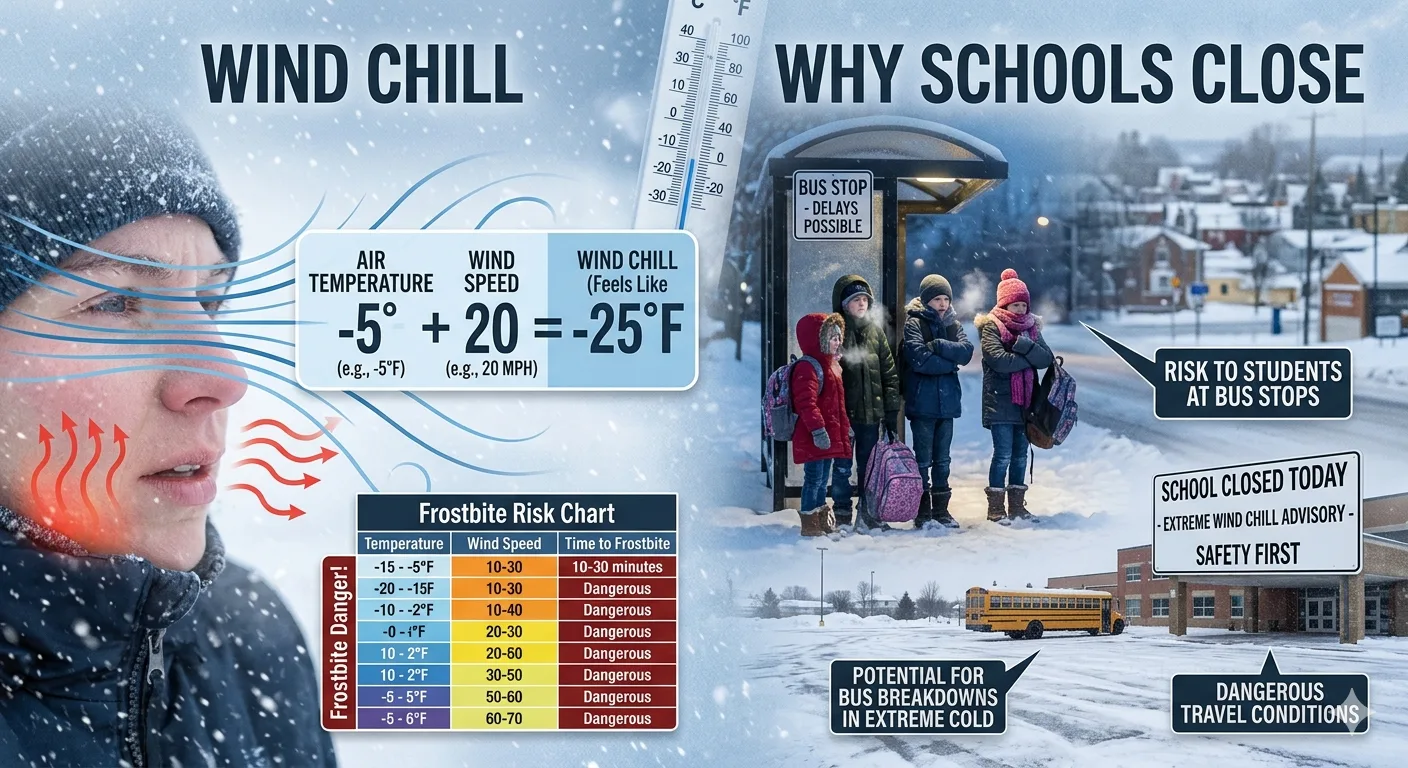
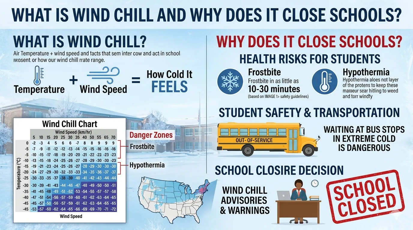
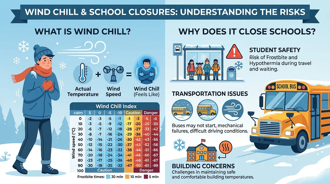
Wind chill is the measure of how cold it actually feels on exposed skin when wind speed is combined with a cold air temperature. It is not a true air temperature reading; rather, it is an index that describes the rate at which the human body loses heat to the surrounding environment. Think of it as a "feels like" temperature designed specifically for human safety.
Your body naturally maintains a thin layer of warm air right against your skin, acting almost like an invisible insulating jacket. When the air is still, this buffer persists and keeps you relatively comfortable even in below-freezing temperatures. But when wind blows, it continuously strips that warm layer away, forcing your body to work harder and harder to replenish the heat it is losing. The faster the wind speed, the faster heat is removed, and the colder you feel.
The Physics of Heat Loss and Convection
The underlying process is convective heat transfer. Convection occurs when moving fluid (air, in this case) displaces the warm air adjacent to a warm surface. As the wind moves across your skin, it replaces the warm boundary layer with colder ambient air. Your body detects the drop in skin surface temperature and responds by increasing blood flow and metabolic heat production, which is why you shiver and feel the chill intensely.
Importantly, wind chill does not lower the actual air temperature. It cannot make inanimate objects like car radiators or water pipes colder than the real thermometer reading. Its effect is exclusive to living beings that generate body heat, making it especially critical to monitor for children, elderly individuals, and anyone working or playing outdoors.
Key Fact: Wind chill only applies to temperatures at or below 50°F (10°C) and wind speeds above 3 mph. Below those thresholds, the wind chill value equals the actual air temperature. Frostbite can also only occur if the actual air temperature is below 32°F (0°C), regardless of how low the wind chill appears.
How Is Wind Chill Calculated? The Official NWS Formula
The concept of wind chill dates back to Antarctic explorers Paul Siple and Charles Passel in 1945, who measured how quickly water froze in plastic containers exposed to varying wind speeds. Their findings laid the groundwork for quantifying wind-related cold, but their formula overestimated the cooling effect on human skin.
In 2001, the U.S. National Weather Service (NWS) and Environment Canada jointly introduced the modern Wind Chill Temperature (WCT) Index. This updated formula was built on advanced heat transfer theory, wind tunnel testing, and clinical trials with human volunteers. It specifically calculates wind speed at 5 feet above ground (average human face height) rather than the standard anemometer height of 33 feet.
Wind Chill (°F) = 35.74 + 0.6215T - 35.75(V^0.16) + 0.4275T(V^0.16)
// Where:
T = Air Temperature in degrees Fahrenheit
V = Wind Speed in miles per hour (mph)
^ = Raised to the power of
You do not need to calculate this by hand. The National Weather Service publishes a wind chill chart that cross-references temperature and wind speed at a glance. The chart also includes frostbite time estimates, making it an invaluable safety tool for schools, parents, and outdoor workers alike.
What the Formula Assumes
- The person is standing outside in an open area facing into the wind.
- There is no solar radiation (the formula assumes the worst case: a clear night sky).
- The calculation applies to the exposed face of an average adult.
- The formula was tested on adult subjects. Children may be even more vulnerable, so extra caution is always recommended.
Wind Chill Risk Chart: How Fast Frostbite Develops
Wind Chill vs. Frostbite Time on Exposed Skin (NWS Data)
Source: National Oceanic and Atmospheric Administration (NOAA), NWS Wind Chill Temperature Index
Wind Chill Reference Table by Temperature and Wind Speed
| Air Temp (°F) | Wind 10 mph | Wind 20 mph | Wind 30 mph | Wind 40 mph | Frostbite Risk |
|---|---|---|---|---|---|
| 30°F | 21°F | 17°F | 15°F | 13°F | Low |
| 20°F | 9°F | 4°F | 1°F | -1°F | Low |
| 10°F | -4°F | -9°F | -12°F | -15°F | Moderate |
| 0°F | -16°F | -22°F | -26°F | -29°F | High (30 min) |
| -10°F | -28°F | -35°F | -39°F | -43°F | Danger (10-30 min) |
| -20°F | -41°F | -48°F | -53°F | -57°F | Extreme (<5 min) |
Source: U.S. National Weather Service Wind Chill Temperature Index Chart. Values are approximate.
Wind Chill Advisory vs. Wind Chill Warning: What Is the Difference?
The National Weather Service issues two distinct cold-weather alerts, and schools use both as key triggers in their closure decision-making process.
Wind Chill Advisory
A Wind Chill Advisory is issued when wind chill values are expected to reach -15°F or colder. Conditions are uncomfortable and potentially hazardous for prolonged outdoor exposure, but the immediate danger is moderate. Under an advisory, most school districts remain open, though bus routes and outdoor activities may be adjusted.
Wind Chill Warning
A Wind Chill Warning is issued when wind chills are expected to reach -25°F or colder. This level signals life-threatening cold. When the NWS issues a Wind Chill Warning, it is highly likely that schools in the affected county will close. Exposed skin can freeze in under 30 minutes, making even a brief wait at a bus stop genuinely dangerous.
"When the National Weather Service issues a Wind Chill Warning for our county for the time the school day begins, we will make a decision to close schools. Buildings and the bus fleet are assessed in the morning prior to school by 6:00 AM."
Boone County School District Official Policy Statement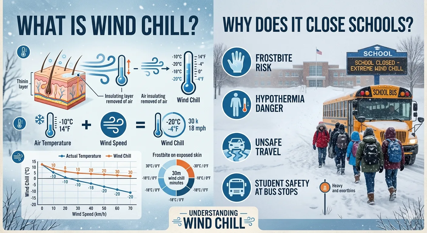
Why Does Wind Chill Close Schools? The Full Decision Framework
School closure decisions are rarely based on a single number. Administrators weigh a complex set of factors simultaneously, and wind chill is one of the most critical variables in that equation. Here is why it carries so much weight.
1. Children Are More Vulnerable to Cold Than Adults
Children have a higher surface-area-to-body-mass ratio than adults, meaning they lose heat more rapidly in cold conditions. Their bodies are also still developing thermoregulatory efficiency, making them more susceptible to frostbite and hypothermia with shorter exposure times. The NWS formula itself was tested exclusively on adult subjects, meaning the actual risk for children at a given wind chill value may be even greater.
Children waiting at bus stops have no way to warm up quickly. They may stand exposed for 5 to 15 minutes or more in extreme cold, a window that, under a Wind Chill Warning, is enough to cause measurable tissue injury to uncovered skin.
2. Bus Fleet Failures in Extreme Cold
School buses rely on diesel fuel and hydraulic brake systems that can fail when temperatures plunge. Diesel gels at around -15°F to -20°F, and battery power drops significantly. Districts typically have maintenance crews out by 4:00-5:00 AM assessing whether the fleet can reliably run. A single bus breakdown in extreme cold with children aboard constitutes a serious emergency.
3. Building and Infrastructure Concerns
School buildings themselves can be compromised by extreme cold. Water pipes can freeze and burst, heating systems become stressed, and gyms or portable classrooms may fail to maintain safe indoor temperatures. Administrators must confirm that every building on every campus is warm and functional before opening.
4. Road Safety and Staff Arrival
Extremely cold conditions often accompany black ice, frozen roads, and drifting snow. Salt loses effectiveness below approximately -9°F, meaning roads that appear treated may still be dangerous. If teachers and staff cannot safely reach school, adequate supervision ratios cannot be maintained.
5. Inadequate Clothing and Walking Students
A significant percentage of students walk to school or are dropped off without proper cold-weather gear. While schools try to provide clothing resources for economically disadvantaged families, a broad wind chill event cannot be managed on an individual basis. Closing school protects the most vulnerable students who may arrive in sneakers and a light jacket on a -30°F wind chill morning.
"Education is a basic civil right to every citizen. When schools close, the loss of education and student learning is always central in the decision. But the safety of the child is first and foremost."
Dr. John Schultz, Superintendent, Hopkins Minnesota School District (via NOAA / National Weather Service)Wind Chill School Closure Thresholds: What Different Districts Use
There is no single federal or state law mandating a specific temperature at which schools must close. Thresholds are set at the district level, which means a school in Wisconsin might close at a different wind chill than one in Ohio or Michigan. Below are real-world examples from school districts across the country.
| School District / State | Wind Chill Closure Threshold | Additional Notes |
|---|---|---|
| Ann Arbor Public Schools (MI) | -20°F or below | Schools closed at or below this wind chill |
| Hamilton School District (WI) | -35°F or below | Advisory (-20°F to -34°F) = schools open |
| CCSD21 Illinois | -30°F sustained WC | Or actual temp -15°F during travel windows |
| Green Bay Area (WI) | -35°F sustained | Above 0°F = outdoor recess still held |
| Washington Local Schools (OH) | -19°F wind chill | Per superintendent statement, Jan. 2024 |
| Lapeer Community Schools (MI) | 30-minute frostbite threshold (NWS chart) | Uses NWS wind chill chart, not fixed number |
| Boone County Schools | NWS Wind Chill Warning issued | Advisory alone = schools likely open |
Notice that thresholds vary significantly. Some districts use a fixed number (like -20°F), while others align with the NWS advisory/warning system, and others use the NWS wind chill chart's frostbite time estimates as their guide. The most safety-conscious approach, used by districts like Lapeer Community Schools, considers the 30-minute frostbite threshold rather than an arbitrary number, because the same wind chill value can represent different real-world dangers depending on actual temperature and wind speed combinations.
When the National Weather Service issues a Wind Chill Warning (wind chills at -25°F or colder), expect school closures. When a Wind Chill Advisory is issued (-15°F to -24°F), schools typically stay open but may limit outdoor activities. Even if school is open, you always have the right to keep your child home and request an excused absence based on weather safety concerns.
Frostbite and Hypothermia: The Real Dangers Behind Wind Chill Closures
Understanding why schools close begins with understanding what happens to the human body in extreme wind chill conditions. Two cold-weather injuries drive these decisions: frostbite and hypothermia.
Frostbite: When Skin Freezes
Frostbite occurs when skin and underlying tissue actually freeze. The body's survival mechanism in extreme cold is to restrict blood flow to the extremities in order to protect vital core organs. This reduction in circulation leaves fingers, toes, ears, the nose, and cheeks dangerously exposed to freezing.
- Frostnip (First Degree): The skin surface begins to freeze. Symptoms include redness, numbness, and a tingling or burning sensation. Frostnip is reversible with prompt rewarming.
- Superficial Frostbite (Second Degree): Skin may freeze and harden. Blisters form within 24 to 48 hours. Permanent damage is possible if not treated promptly.
- Deep Frostbite (Third and Fourth Degree): All layers of skin and underlying tissue freeze. The affected area becomes hard, waxy, and colorless. Permanent damage, including potential amputation, is a serious risk.
At a wind chill of -20°F, exposed skin can develop frostbite in as little as 30 minutes. At -45°F wind chill, frostbite can occur in under 5 minutes. A child standing at a bus stop for 10 minutes in such conditions faces very real, permanent injury.
Hypothermia: When Core Temperature Drops
Hypothermia occurs when the body's core temperature falls below 95°F (35°C), from a normal of 98.6°F. It can happen even at temperatures well above freezing (as high as 60°F) if a person is wet, improperly dressed, or exposed for extended periods.
- Mild hypothermia (95°F to 90°F): Uncontrollable shivering, confusion, impaired coordination.
- Moderate hypothermia (90°F to 82°F): Shivering stops (a dangerous sign), severe confusion, drowsiness.
- Severe hypothermia (below 82°F): Unconsciousness, irregular heartbeat, risk of death if untreated immediately.
Wind chill dramatically accelerates the onset of hypothermia by removing the warm air layer that normally insulates the body. A child who is wet from playing in snow and standing in a strong wind faces hypothermia risk far faster than the thermometer alone would suggest.
What Parents Should Do on Extreme Wind Chill Days
Whether school is open or closed, parents play a vital role in keeping children safe during cold snaps. Here are the most important steps to take.
Dress Children in Proper Layers
- Base layer: A moisture-wicking material (polyester or merino wool) that pulls sweat away from the skin.
- Middle layer: Insulating fleece or wool to trap body heat.
- Outer layer: A wind-resistant, water-repellent shell to block the wind's stripping effect.
- Always add a warm hat that covers the ears, insulated mittens (warmer than gloves), a scarf or balaclava, and waterproof boots.
Know the Warning Signs of Cold Injury
- Numbness, tingling, or a burning sensation in fingers, toes, ears, or the nose.
- Skin that turns pale, white, or gray and feels hard to the touch.
- Uncontrollable shivering, slurred speech, confusion, or extreme drowsiness (hypothermia signs).
Have a Cold-Weather Emergency Plan
- If your child walks or takes a bus, identify warm shelter points (convenience stores, libraries, neighbors) along the route in case of a bus delay or breakdown.
- Older children who drive should keep a winter emergency kit in the car: blankets, hand warmers, a charged phone, and a small shovel.
- Know your district's closure communication channels (app, social media, local radio, automated phone calls) so you are not caught off guard.
"Our schools work really well with our families to make sure that if families don't have snow pants, boots, gloves, or hats, our schools do a lot of collections for those things."
Lori Blakeslee, Director of Communications, Green Bay Area Public School District (via Fox Weather)The Polar Vortex and Its Role in Extreme Wind Chill Events
Many of the most severe wind chill events that close schools across large regions are linked to polar vortex disruptions. The polar vortex is a large area of low pressure and cold air surrounding the Earth's poles. Normally, the jet stream keeps this frigid air locked near the Arctic. But when the jet stream weakens or becomes wavy, large pockets of polar air can plunge southward into the continental United States.
When a polar vortex intrusion occurs, wind chills can reach -30°F to -60°F across wide swaths of the Midwest and Northeast. These events can last several days and often result in multi-day school closures across dozens of districts simultaneously. The 2019 polar vortex event, for example, brought wind chills below -50°F to parts of the Midwest, prompting closures of entire city school systems.
Climate scientists note that polar vortex events may become more variable due to changes in Arctic warming, though ongoing research continues to refine exactly how these patterns will shift over coming decades.
Wind Chill Closures and the Rise of E-Learning Days
One significant shift in how schools respond to wind chill closures has been the widespread adoption of E-Learning Days (also called remote learning days or virtual school days). Rather than losing instruction time entirely, districts can now flip to online learning when conditions are too dangerous for in-person attendance.
E-Learning days typically require all students to have access to a device and internet connection, which is why they cannot be used universally during, for example, major power outages. However, for pure cold-weather closures, they provide an effective way to maintain academic continuity without putting students at risk.
Districts that use E-Learning on wind chill days often do not need to make up the missed day at the end of the school year, reducing the disruption to summer schedules and contractual commitments for staff.
Conclusion: Wind Chill Is a Genuine Safety Threat, Not a Convenience
Wind chill is far more than a number on a weather app. It represents a measurable, science-backed rate of heat loss from the human body, and when it reaches dangerous levels, it can cause permanent physical harm in minutes, especially to children. School administrators who close for wind chill are not being overly cautious; they are applying rigorous safety science to protect thousands of young people who have no choice but to stand, walk, or ride through that cold.
Understanding the difference between a Wind Chill Advisory and a Wind Chill Warning, knowing your district's specific closure threshold, and dressing your children appropriately every winter morning are the three most powerful things a parent can do to navigate cold-weather school decisions with confidence. Stay warm, stay informed, and trust the science.
Also Checkout :