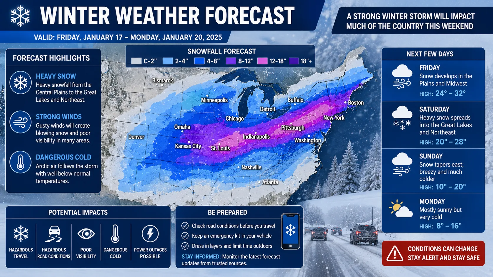
A winter weather forecast tells you what kind of cold-season conditions are coming, whether that means a specific storm three days out or the broader pattern for the entire season. Good forecasts combine short-range storm tracking with longer seasonal outlooks so you can plan both this week's commute and this year's winter overall.
This guide breaks down how winter weather forecasts are built, what the different alert levels actually mean, and how to use a winter weather forecast calculator to get a forecast tailored to your exact location instead of a broad regional summary. Whether you're a parent checking tomorrow's commute, a school administrator weighing a delay, or someone planning a weekend trip, the goal is the same: read the forecast correctly so you can act on it with confidence.
What Is a Winter Weather Forecast?
A winter weather forecast is a prediction of cold-season conditions such as snow, ice, wind chill, and freezing rain for a specific location and time frame. It can be short-range, covering the next 24 to 72 hours with high confidence, or long-range, covering an entire season with a general trend rather than a precise number.
A complete winter weather forecast typically includes:
- Precipitation type, meaning snow, sleet, freezing rain, or plain rain
- Timing, or when conditions are expected to start and end
- Temperature and wind chill for the forecast period
- Alert level, such as an advisory, watch, or warning
- Confidence rating, reflecting how much forecast models agree
Agencies like the National Weather Service issue these forecasts and update them as new data arrives, which is why the outlook for Friday can look noticeably different on Monday than it does on Thursday.
How Winter Weather Forecasts Work
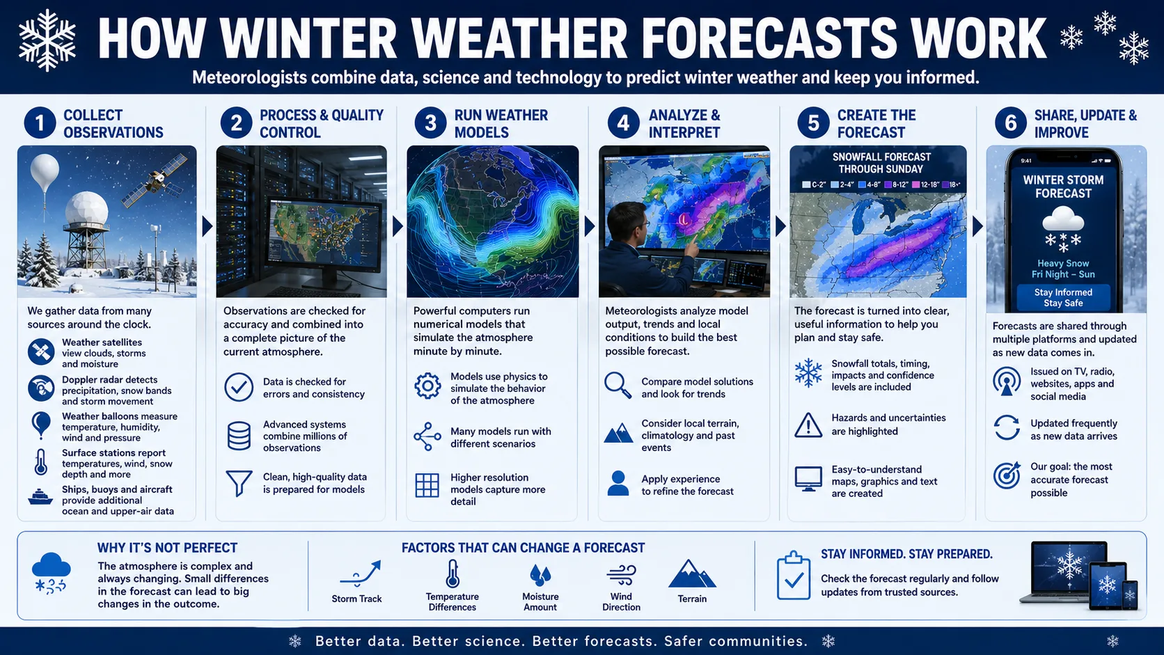
Winter weather forecasts are built by layering multiple types of information: current observations, computer models, and, for seasonal outlooks, long-range climate patterns.
Short-Range Forecasts vs. Seasonal Outlooks
Short-range forecasts, covering the next one to seven days, rely heavily on radar, satellite, and atmospheric models that simulate hour-by-hour conditions. These forecasts are generally reliable and get more precise the closer you get to the event.
Seasonal outlooks work differently. They look months ahead using large-scale climate signals, most notably El Nino and La Nina ocean patterns, which influence storm tracks across an entire winter. A seasonal outlook cannot tell you if it will snow on a specific Tuesday in January, but it can suggest whether your region is likely to see an above-normal or below-normal winter overall.
The Data and Models Behind Every Forecast
Short-range winter forecasts pull from several live sources at once:
- Doppler radar tracking precipitation as it develops and moves
- Surface weather stations reporting live temperature and pressure readings
- Weather balloons measuring conditions at different altitudes
- Computer models such as the GFS, NAM, and European ECMWF, which simulate how the atmosphere will evolve
Meteorologists compare these models, note where they agree or disagree, and issue a forecast that reflects the most likely outcome along with a confidence level. When models disagree sharply, forecasters often present a wider range of possible outcomes rather than a single number.
Temperature is worth special attention because it works at two levels at once. Surface temperature determines whether precipitation melts as it lands, while the temperature higher in the atmosphere, where the precipitation actually forms, determines whether it starts out as snow, sleet, or rain in the first place. A storm can have cold air at the surface but a warm layer several thousand feet up, producing freezing rain instead of the snow a surface-only reading might suggest.
How Seasonal Outlooks Are Built
Seasonal winter outlooks rely on entirely different inputs than short-range forecasts. Instead of tracking a single storm, forecasters study large-scale ocean temperature patterns, particularly in the Pacific, along with historical analog years that shared similar conditions. These patterns influence the position of the jet stream for months at a time, which in turn shapes which regions tend to see more storms, colder air, or drier stretches across an entire season.
Because seasonal outlooks work at this broader scale, they are best understood as a probability lean rather than a guarantee. An outlook calling for a snowier than normal winter in one region simply means the odds are tilted in that direction compared to a typical year, not that every storm will be confirmed months in advance.
Reading Winter Weather Alerts Correctly
One of the most misunderstood parts of any winter weather forecast is the alert language attached to it. These terms are not interchangeable, and knowing the difference changes how seriously you should treat the forecast.
Advisory, Watch, and Warning Explained
- Winter Weather Advisory: Conditions are expected to cause inconvenience and some hazard, but not enough to be life threatening on their own. Roads may be slick and travel slower than usual.
- Winter Storm Watch: Conditions favorable for a significant winter storm are possible, usually issued 24 to 48 hours in advance. This is a heads-up to start planning, not a confirmed event.
- Winter Storm Warning: A significant winter storm is occurring or is about to occur, with confidence high enough to expect real disruption to travel and daily activities.
Understanding this hierarchy helps you separate a routine forecast from one that genuinely warrants changing your plans.
Other Terms Worth Knowing
Beyond the three main alert types, a few additional terms show up regularly in winter forecasts and are worth understanding.
- Wind Chill Advisory or Warning: Issued when cold temperatures combined with wind create a dangerous "feels like" temperature, even if snow is not part of the forecast at all.
- Ice Storm Warning: A more specific version of a winter storm warning, issued when significant ice accumulation is expected, which tends to cause more infrastructure damage than an equivalent amount of snow.
- Blizzard Warning: Reserved for conditions combining sustained strong winds, heavy blowing snow, and dramatically reduced visibility for an extended period, not just heavy snowfall alone.
How Forecast Confidence Is Calculated
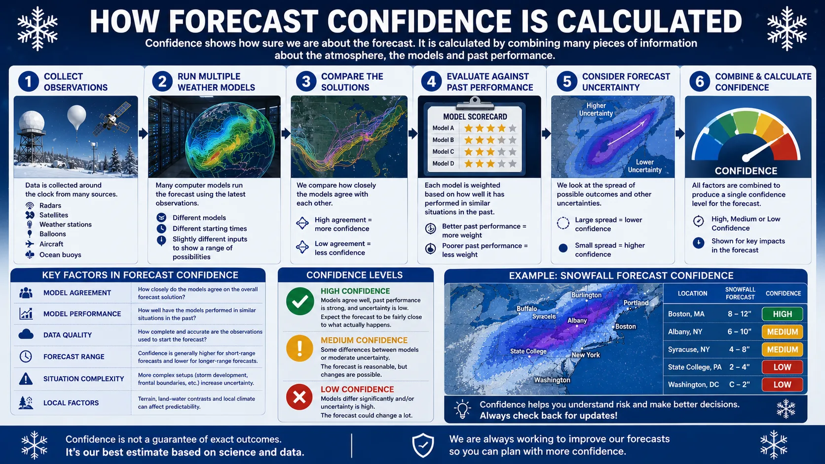
Behind every winter weather forecast is a confidence rating that tells you how much to trust the specific numbers being shown. This rating is not guesswork. It comes from comparing how closely different weather models agree with each other.
Model Agreement and Ensemble Forecasting
Forecasters run the same weather models dozens of times with slightly different starting conditions, a technique called ensemble forecasting. If most of those runs land in a similar range, confidence is high. If the runs scatter widely, from a near miss to a major storm, confidence is low and the forecast is presented as a wider range.
Simplified confidence logic: High model agreement + close event timing = high confidence. Low model agreement + distant event timing = low confidence.
Why Confidence Changes as the Event Gets Closer
As a storm approaches, forecasters gain access to more real-time radar and station data, which narrows the range of likely outcomes. This is why a forecast issued five days out might carry only moderate confidence, while the same event issued the morning it happens often carries high confidence.
It helps to think of a winter weather forecast less like a fixed answer and more like a snapshot of the best available evidence at that moment. The underlying event, whether that is a storm system or a seasonal pattern, does not actually change as the forecast updates. What changes is how much information forecasters have to describe it accurately.
How to Use a Winter Weather Forecast Calculator
Getting a location-specific winter forecast takes less than a minute using the tools in our calculator directory.
- Enter your ZIP code or city. This pulls live data specific to your location rather than a broad state-level summary.
- Choose your forecast window. Select the next 24 hours for immediate planning or the extended outlook for the week ahead.
- Check the alert level. Look for whether an advisory, watch, or warning has been issued for your area.
- Review the confidence rating. A high-confidence forecast is more actionable than a low-confidence one issued several days out.
- Compare regional context. Use our state-by-state predictions to see how nearby areas are affected by the same system.
- Recheck closer to the event. Forecasts sharpen significantly inside the 24-hour window before conditions arrive.
Most people find it useful to check the forecast twice, once the evening before a possible event to plan ahead, and again first thing in the morning to confirm timing before heading out.
Why Winter Weather Forecasts Matter
A reliable winter weather forecast shapes decisions that go well beyond curiosity about the weather.
- School and work planning: Districts and employers use alert levels and timing to decide on delays or closures.
- Travel safety: Knowing exactly when conditions worsen helps drivers avoid the riskiest hours on the road.
- Event scheduling: Families and businesses can shift plans around confirmed high-impact windows instead of guessing.
- Emergency preparedness: Cities use forecasts to time road treatment, plowing routes, and staffing levels.
- Seasonal planning: Long-range outlooks help ski resorts, farmers, and municipalities budget and prepare months ahead.
These use cases share a common thread. The earlier someone identifies a meaningful weather risk, the more time they have to respond calmly instead of reacting at the last minute. A family that checks a forecast the night before a storm can prepare a car with supplies and adjust morning routines, while one that only checks after waking up to snow already falling has far fewer options.
Real-World Example: Reading a 5-Day Winter Outlook
Here is how a typical 5-day winter weather forecast might look, and how confidence naturally shifts as each day gets closer.
| Day | Forecast | Alert Level | Confidence |
|---|---|---|---|
| Day 1 (today) | Light snow, 1 to 2 inches | None | High |
| Day 2 | Clear, cold | None | High |
| Day 3 | Possible winter storm, 4 to 9 inches | Winter Storm Watch | Moderate |
| Day 5 | Uncertain, wide range possible | None yet issued | Low |
Notice that Day 3 carries a watch instead of a warning. That reflects real uncertainty about the storm's exact track and intensity, which typically resolves into a firmer warning or advisory as the event gets closer. Day 5 shows almost no detail yet, since forecasts that far out are still working with limited model agreement.
[Suggested image placement: A simple 5-day forecast strip graphic showing icons for each day's conditions and confidence level, alt text: "5 day winter weather forecast confidence chart"]
Winter Weather Forecasts by Region
The same national storm system can produce very different winter weather forecasts depending on where you live.
Northeast and Coastal Systems
Coastal storms in this region can intensify quickly and shift track with little notice, which is why forecasts here often carry a wider range until the storm is within 24 to 48 hours of arrival.
Great Lakes and Lake-Effect Bands
Lake-effect snow creates narrow, intense bands that can dump far more snow in one town than a neighboring town just a few miles away. Forecasts in this region often include a band-specific caveat rather than a single county-wide number.
Mountain West and Elevation Effects
Elevation plays an outsized role here. A valley town might see rain from the same system that drops heavy snow at a nearby ski resort a few thousand feet higher, so forecasts are often given as an elevation-based range.
South and Transition Zones
Areas that see winter weather only occasionally face a different challenge. Even a modest forecast of light snow or ice can carry outsized impact where road crews and drivers have less experience with winter conditions.
Because these patterns vary so much by geography, it's worth comparing your local forecast to nearby areas using our state-by-state predictions page before finalizing travel or event plans. A forecast that looks routine at the state level can hide meaningful differences between two towns just a short drive apart.
Read More : Snowfall Predictions 2026
Common Mistakes and Pro Tips
Common Mistakes When Reading a Winter Weather Forecast
Most confusion around winter weather forecasts comes from misreading them, not from the forecast itself being wrong. These are the mistakes we see most often.
- Treating a watch like a warning. A watch means conditions are possible, not confirmed. Overreacting to a watch can lead to unnecessary panic.
- Ignoring the confidence rating. A low-confidence forecast five days out is a rough outlook, not a firm plan.
- Focusing only on temperature. Wind chill and precipitation type often matter more for real-world impact than the raw temperature number.
- Checking the forecast only once. Winter forecasts update as new data comes in, especially inside 24 hours of an event.
- Assuming a seasonal outlook predicts specific storms. A seasonal outlook describes a general trend for the whole winter, not individual storm dates.
- Comparing forecasts from different sources without checking update times. A forecast from an hour ago and one from yesterday afternoon are not equally current, even if both claim to cover the same day.
Pro Tips for More Reliable Results
- Check the forecast the night before and again the morning of a possible event for the tightest range.
- Pair temperature with wind speed. Use our wind chill calculator alongside your forecast to understand the full safety picture.
- Watch the alert level upgrade path. A watch that upgrades to a warning is a strong signal that confidence has increased significantly.
- Use your local closure history. Some areas act on advisories, others only on warnings, so pair the forecast with your area's typical response pattern.
Forecast Types Compared
| Forecast Type | Time Range | Best For | Limitation |
|---|---|---|---|
| ZIP-code winter forecast calculator | Hourly updates, 1 to 7 days | Personalized, location-specific planning | Requires an internet connection to refresh |
| National weather app | Daily updates | Quick regional overview | Less precise for small or rural towns |
| Seasonal outlook | Full winter season | Long-range planning and budgeting | Cannot predict individual storm dates |
For day-to-day accuracy, a location-specific calculator checked close to the event will consistently outperform a general seasonal outlook. Explore our full calculator directory to pair your winter weather forecast with related tools like the rain delay calculator for mixed precipitation events.
None of these tools are meant to replace an official forecast from your local weather service or a closure decision from your school district. They are meant to give you a head start so you are not caught off guard when the official word arrives.
Conclusion
A winter weather forecast is only as useful as your ability to read it correctly. By understanding the difference between an advisory, a watch, and a warning, checking the confidence rating alongside the conditions, and rechecking as an event approaches, you can plan around winter weather with far more confidence than a quick glance at a temperature icon allows.