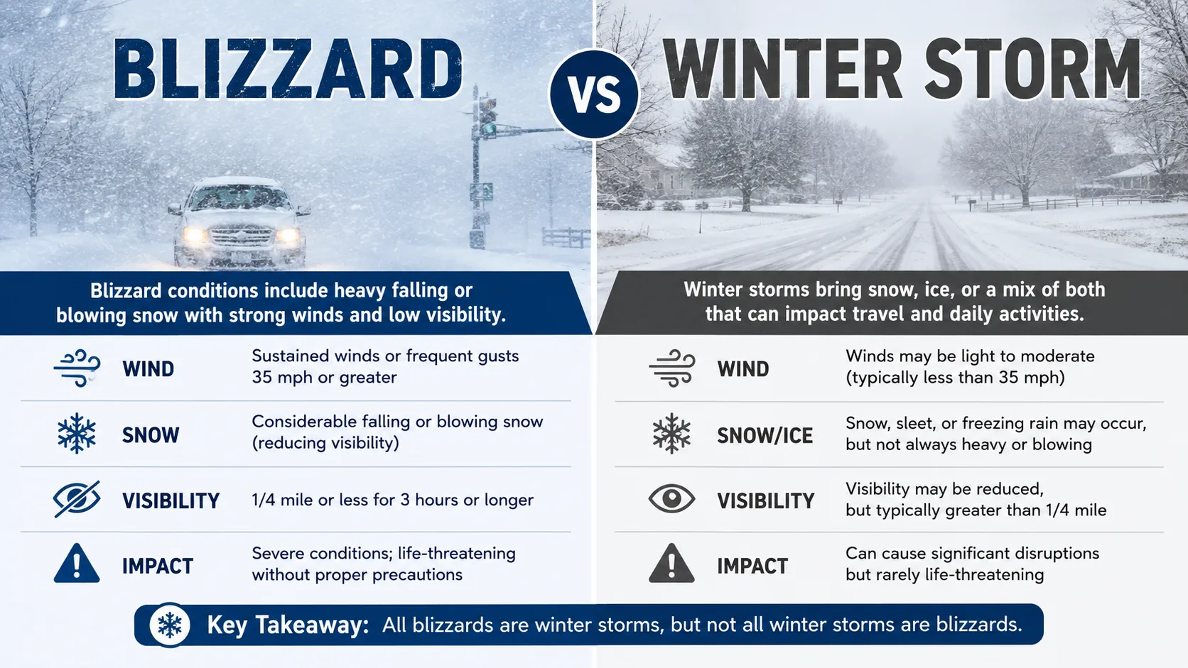
The short answer: a winter storm is any storm that produces snow, sleet, or freezing rain, while a blizzard is a specific, official category of severe winter storm defined by three strict conditions. Sustained winds of at least 35 mph, visibility dropping to a quarter mile or less because of blowing snow, and those conditions lasting for a minimum of three hours in a row. In other words, every blizzard is a winter storm, but most winter storms never become blizzards.
If you have ever wondered why the weather app calls one storm a "winter storm warning" and another a "blizzard warning," this guide breaks down exactly what separates the two, how meteorologists measure it, and how you can check your own local risk using our free tools.
What Is a Winter Storm?
A winter storm is a broad, general term. It describes any weather system that produces cold-season precipitation, including snow, sleet, freezing rain, or a mix of all three. Winter storms can be mild, dropping an inch of slush overnight, or they can be massive systems that shut down entire regions.
What all winter storms share is temperature. The air near the ground has to be cold enough, generally at or below 32°F, for precipitation to fall as snow or ice rather than plain rain. Beyond that, a winter storm does not need to meet any wind speed or visibility standard.
- Precipitation: snow, sleet, freezing rain, or a combination
- Wind: can be calm, breezy, or gusty, with no minimum required
- Visibility: may be reduced, but there is no official threshold
- Duration: anywhere from a few hours to several days
What Is a Blizzard?
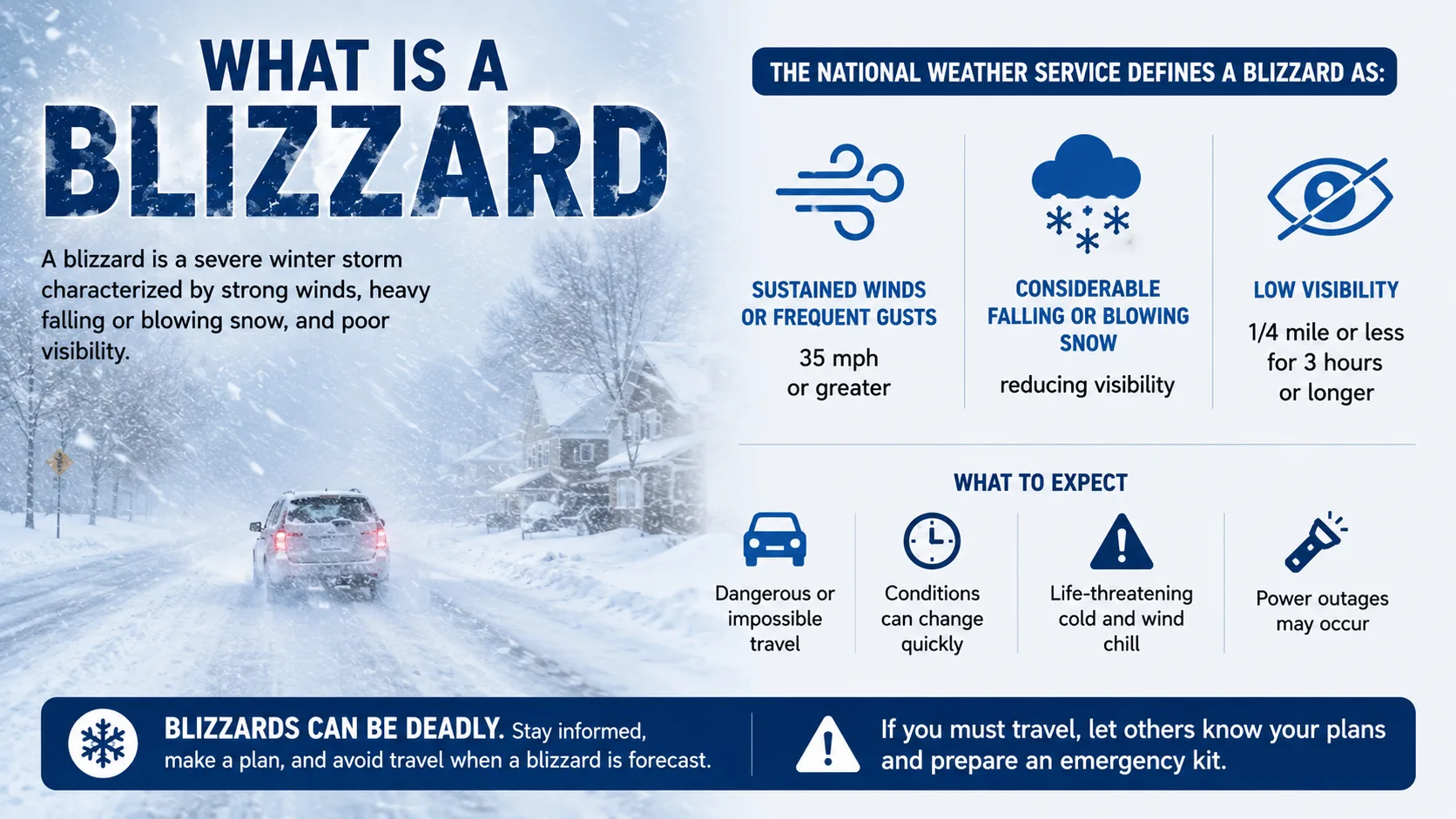
A blizzard is a winter storm that has crossed a specific, measurable threshold. The National Weather Service only uses the word "blizzard" when a storm meets all three of the following conditions at the same time, for at least three hours straight:
- Sustained winds or frequent gusts of 35 mph or higher
- Falling or blowing snow that cuts visibility to a quarter mile or less
- Those two conditions lasting three hours or longer
Notice what is missing from that list: a snowfall total. A storm does not need to drop a single new inch of snow to qualify as a blizzard. If strong wind picks up snow that is already sitting on the ground and blows it around hard enough to drop visibility to near zero, meteorologists call that a ground blizzard, and it counts under the same rule.
Key takeaway: The difference between a blizzard and a winter storm comes down to wind and visibility, not snowfall amount. A two-inch snowfall with 40 mph winds can be declared a blizzard, while a two-foot snowfall with light wind never will be.
Blizzard vs Winter Storm: The Real Difference
Wind Speed
This is the single biggest separator. Winter storms have no wind requirement at all. A blizzard needs sustained winds or frequent gusts of at least 35 mph, strong enough to physically pick up loose snow and throw it sideways.
Visibility
In an ordinary winter storm, you can usually still see a block or two down the street, even during heavy snowfall. In blizzard conditions, wind-driven snow can create whiteout conditions, cutting visibility to a quarter mile or less, sometimes down to just a few feet.
Duration
A brief burst of strong wind and snow does not count as a blizzard. The National Weather Service requires the combined wind and visibility criteria to hold steady for three hours or more before the term applies.
Temperature
Temperature is not officially part of the blizzard definition, but in practice, blizzards almost always happen when it is bitterly cold, frequently below 20°F. That combination of high wind and low temperature is also why blizzards carry a serious frostbite and hypothermia risk. You can check how dangerous the wind chill is likely to get with our Wind Chill Calculator before heading outside.
How Meteorologists Calculate Blizzard Conditions
Forecasters do not guess whether a storm qualifies as a blizzard. They watch three live data streams at the same time:
- Anemometer readings for sustained wind speed and gust frequency
- Visibility sensors at airports and weather stations tracking how far light can travel through falling or blowing snow
- A running three-hour clock that resets if conditions briefly improve
Only when all three line up, wind at or above 35 mph, visibility at or below a quarter mile, and a duration of three hours or longer, does the National Weather Service issue or upgrade a warning to reflect blizzard conditions.
Step-by-Step: Checking Whether You're Facing a Blizzard or a Regular Winter Storm
You do not need a meteorology degree to get a quick read on your own local risk. Here is a simple process:
- Check your local forecast for the specific wording used. "Winter Storm Warning" and "Blizzard Warning" are not interchangeable, and the National Weather Service chooses the label deliberately.
- Look at the forecast wind speed alongside the snowfall forecast. High snow totals with low wind is a heavy winter storm, not a blizzard.
- Run your location through a snow day predictor like the one on our homepage, which factors in snowfall, timing, and local school closure history together.
- Check statewide patterns if you are trying to plan travel or judge regional risk using our state-by-state predictions page.
- Watch for whiteout language in advisories. Phrases like "near-zero visibility" or "life-threatening travel conditions" almost always signal blizzard-level wind, not just heavy snow.
Comparison Table: Blizzard vs Winter Storm at a Glance
| Factor | Winter Storm | Blizzard |
|---|---|---|
| Wind speed | No minimum required | 35 mph sustained or frequent gusts |
| Visibility | No official threshold | 1/4 mile or less |
| Minimum duration | Not defined | 3 hours or longer |
| Snowfall required | Yes, some form of cold-season precipitation | Not required, only blowing or falling snow reducing visibility |
| Typical temperature | At or below 32°F | Often below 20°F |
| NWS warning type | Winter Storm Warning | Blizzard Warning |
Real-World Examples With Numbers
Example 1: A heavy winter storm that is not a blizzard. A coastal city gets 14 inches of wet, heavy snow overnight, but wind stays under 15 mph the entire time. Visibility drops but never falls below half a mile. This is a significant winter storm, and travel is dangerous, but it does not meet the blizzard criteria.
Example 2: A blizzard with modest snowfall. A Plains town only receives 3 new inches of snow, but a strong cold front pushes sustained winds to 45 mph for six straight hours. Loose snow on the ground gets whipped into the air, cutting visibility to under a quarter mile the entire time. Despite the low snow total, this officially qualifies as a blizzard, and in fact a ground blizzard specifically.
Example 3: The historical benchmark. One of the most severe blizzards in U.S. history dropped as much as 50 inches of snow across parts of the Northeast, paired with hurricane-force wind gusts and drifts that buried multi-story buildings. That combination of extreme snowfall and extreme wind is rare, which is exactly why true blizzards are less common than ordinary winter storms.
Common Mistakes People Make
- Assuming heavy snowfall automatically equals a blizzard. Snow totals alone never determine the label. Wind and visibility do.
- Ignoring a "Winter Storm Watch" because it doesn't say blizzard. A watch means conditions are possible, and it can still be upgraded quickly as wind data comes in.
- Confusing a blizzard warning with a general cold weather alert. A blizzard warning is specifically about wind-driven, low-visibility snow, not just cold temperatures.
- Not checking wind chill separately. Since blizzards often bring dangerously low wind chill, it is worth running the numbers with our Wind Chill Calculator before any outdoor activity.
- Assuming a ground blizzard is less serious. Because no new snow is falling, some people underestimate ground blizzards, even though visibility can be just as poor as in a classic blizzard.
Blizzard Warning vs Winter Storm Warning vs Winter Storm Watch
These three terms sound similar but mean very different things:
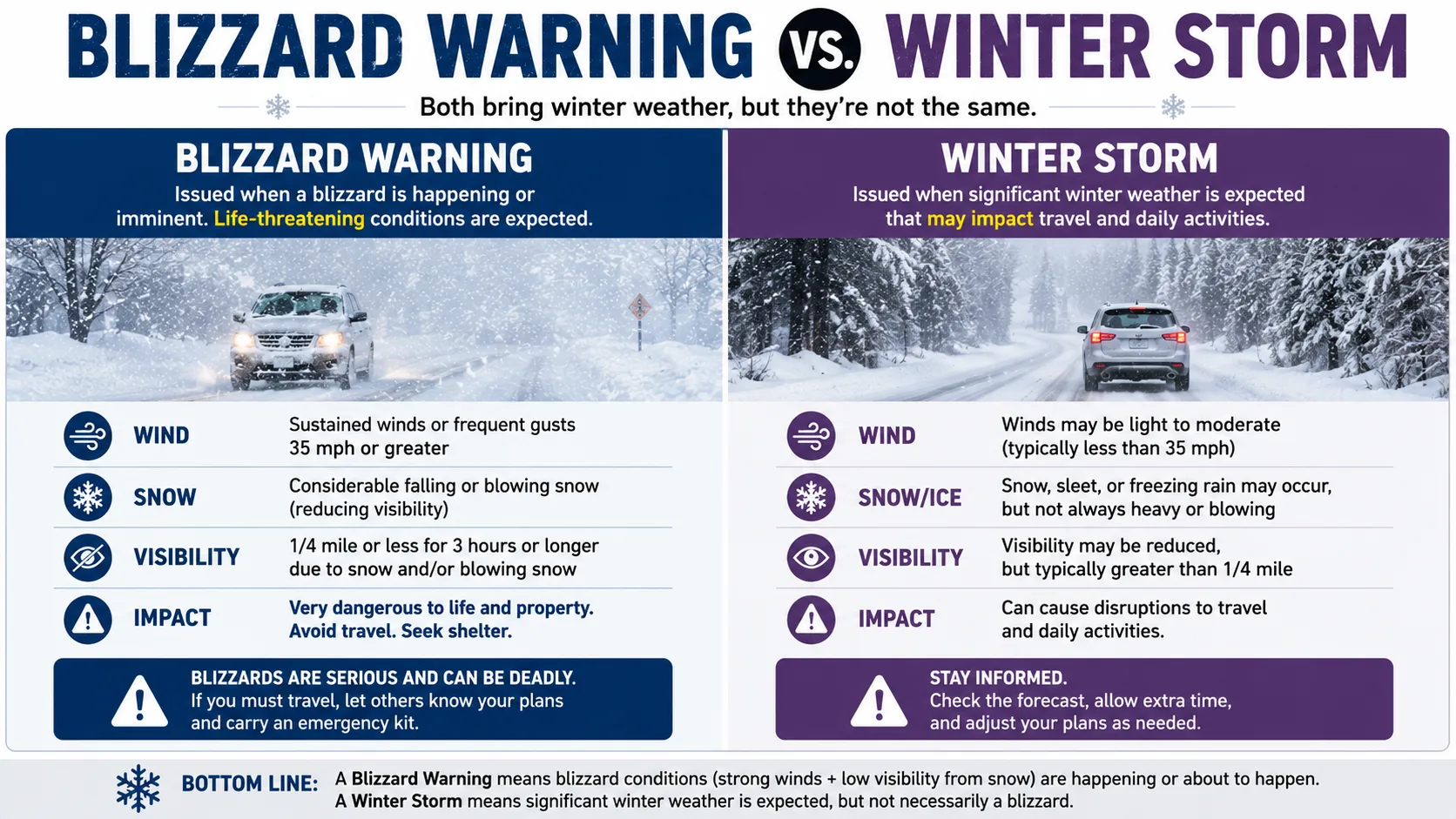
- Winter Storm Watch: Conditions favorable for a significant winter storm are possible in the next day or two. Nothing is confirmed yet.
- Winter Storm Warning: A significant winter storm, meaning heavy snow, ice, or a mix, is happening or about to happen. Blizzard-level wind is not guaranteed.
- Blizzard Warning: The National Weather Service expects or is already observing sustained wind at or above 35 mph combined with visibility at or below a quarter mile for three hours or more. This is the most serious of the three.
Read More : What Is Lake Effect Snow
Related Winter Weather Terms Worth Knowing
Nor'easter: A powerful low-pressure system that forms along the Mid-Atlantic coast and moves northeast, often producing heavy snow, coastal flooding, and strong wind, though technically a nor'easter does not even require snow to occur.
Snow squall: A short, intense burst of heavy snow and gusty wind that drops visibility fast but usually lasts less than an hour, too brief to meet the blizzard duration requirement.
Ground blizzard: Blizzard-level wind and visibility caused entirely by wind lifting snow already on the ground, with no new snow necessarily falling from the sky.
To browse tools for these related conditions and more, our full calculator directory covers everything from wind chill to rain delay predictions in one place.
Pro Tips for Staying Safe in Either Type of Storm
- Charge phones and backup batteries before a storm arrives, since blizzards frequently knock out power for hours or days.
- Avoid driving once a blizzard warning is active. Whiteout conditions can drop visibility to near zero with almost no warning.
- Keep an emergency kit in the car during winter storm season, including blankets, water, and a flashlight.
- Check both the snowfall forecast and the wind forecast, not just one or the other, to understand your real risk.
- If schools or workplaces are watching conditions closely, our snow day calculator can give you an early, data-based read on the odds of a closure.
What Experts Say
The National Weather Service has been consistent for decades that the defining trait of a blizzard is wind, not snowfall, a distinction that surprises many people who assume the two terms are interchangeable. Regional forecast offices across the Northern Plains and Upper Midwest, the areas that see blizzards most often in North America, repeatedly note that ground blizzards catch residents off guard specifically because no fresh snow appears to be falling.
Meteorologists reviewing major historical storms, including the Great Blizzard of 1888 and the Great Midwest Blizzard of 1967, point to the same pattern every time: it was the combination of extreme wind and extended duration, not snowfall totals alone, that earned those storms the blizzard label and made them so dangerous.
Conclusion
A winter storm is any cold-season storm that produces snow, sleet, or freezing rain, while a blizzard is a specific, measurable category defined by sustained wind of 35 mph or higher, visibility at a quarter mile or less, and a duration of at least three hours. Snowfall totals do not determine the label. Wind and visibility do.
Understanding this difference helps you take weather alerts seriously and plan ahead with confidence. Try the calculator above to see your local snow day odds, or explore o