Everything you need to know about one of winter's most powerful and localized weather phenomena, from how it forms to where it strikes hardest.
Lake effect snow is one of the most dramatic, misunderstood, and scientifically fascinating weather phenomena in North America. It can bury a single town under five feet of snow in 24 hours while the city just ten miles away barely sees a flurry. It shuts down highways, grounds flights, and transforms communities into isolated winter islands overnight.
Yet for all its ferocity, lake effect snow is not random. It is a product of precise atmospheric physics, wind direction, lake temperature, and geography working together in a chain reaction that forecasters still struggle to pin down with accuracy.
In this complete guide, we break down lake effect snow explained from its basic definition through the advanced science, its most destructive historical events, the snowbelt regions it dominates, and what climate change means for its future. Whether you are a weather enthusiast, a student, or someone planning a winter trip through upstate New York, this is the definitive resource.
What Is Lake Effect Snow?
At its core, lake effect snow is a localized snowfall event triggered when cold, dry air moves across the relatively warm, open surface of a large lake. The lake heats and moistens the air from below. That warmed, moisture-laden air rises rapidly, cools as it climbs, and condenses into dense snow clouds that then dump their load on the downwind (leeward) shore.
The result is snowfall that is hyper-localized, intense, and sometimes violent. A snowband of fewer than three miles wide can produce two to three inches of snow per hour, and in extreme cases far more. Towns directly in the band get buried; communities just outside it see sunshine.
This phenomenon is most famous around North America's Great Lakes (Superior, Michigan, Huron, Erie, and Ontario), but it also occurs around the Great Salt Lake in Utah, Lake Baikal in Russia, the western coasts of Japan, and even some large saline bodies of water where a similar process is called ocean-effect or bay-effect snow.
Key Definition
Lake effect snow forms when cold arctic air (often from Canada) sweeps over warmer, unfrozen lake water. The temperature contrast drives moisture and heat into the lower atmosphere, creating narrow but intense bands of snow that fall primarily on downwind shorelines and nearby terrain. It is fundamentally different from frontal snowstorms produced by low-pressure weather systems.
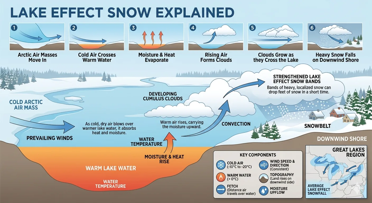
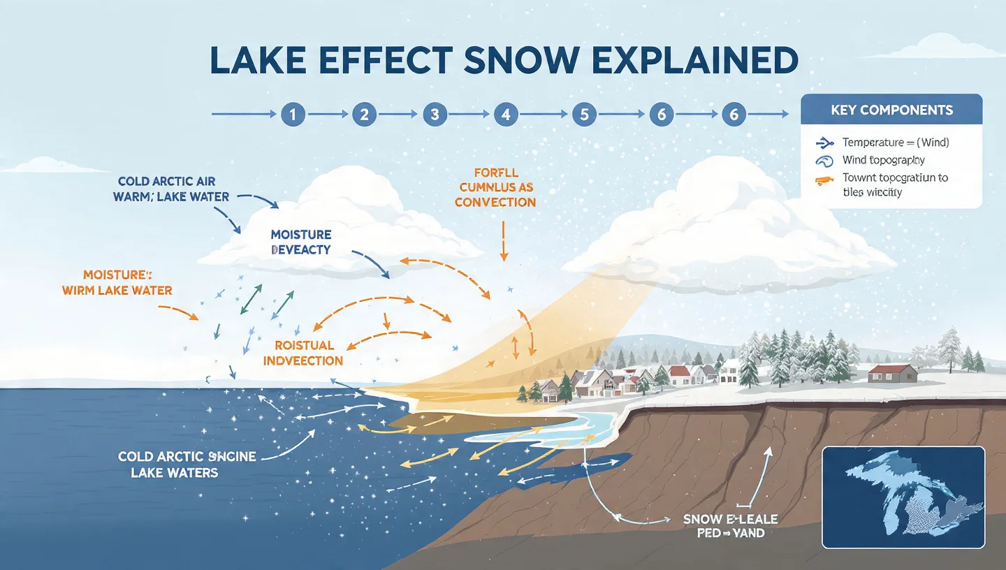
How Does Lake Effect Snow Form? Step by Step
Understanding how lake effect snow forms requires following the journey of a cold air mass from the moment it crosses the lake surface to the moment snow falls on land. Here is the process in clear stages:
Arctic Air Descends
Cold, dry air masses originate from Canada and sweep southward or southeastward across the Great Lakes region, typically driven by high-pressure systems and northwest winds in late autumn and winter.
Cold Air Meets Warm Lake Water
The air, which may be near or below freezing, moves over lake water that is still relatively warm (often in the 40s to 50s Fahrenheit in late fall). The temperature differential drives the entire system. A difference of at least 23°F (13°C) between the lake surface and the air at roughly 5,000 feet of altitude is typically required for vigorous lake effect activity.
Heat and Moisture Transfer
The lake rapidly transfers heat and water vapor into the lowest layer of the atmosphere. The bottom of the cold air mass warms and picks up humidity. Contrary to popular belief, most of the moisture for lake effect snow actually comes from the cold air itself, not just the lake surface. The lake primarily energizes and organizes the system.
Convection and Cloud Formation
The warmed, moist air is less dense than the air above it, so it rises vigorously. As it climbs, it cools and its water vapor condenses into clouds. These clouds grow and intensify over the open water, forming elongated bands aligned with the prevailing wind.
Snow Falls on the Downwind Shore
The snowband reaches land and drops its frozen payload. The heaviest snow typically falls within 40 kilometers (25 miles) of the shoreline, though bands can carry precipitation up to 150 kilometers (about 90 miles) inland, especially where terrain enhances uplift.
The 5 Key Ingredients for Lake Effect Snow
Meteorologists look for specific conditions, called key ingredients, when determining whether lake effect snow will develop, how intense it will be, and exactly where it will fall. All five must align for a significant event.
- Temperature Differential (Instability): The difference between the lake surface temperature and the air temperature at approximately 850 millibars (about 5,000 feet altitude) must be at least 23°F (13°C). Greater differentials produce stronger convection and heavier snowfall.
- Fetch (Over-Water Distance): Cold air needs to travel at least 100 kilometers (60 miles) over open water to fully pick up heat and moisture. Longer fetches generally produce more precipitation and more intense snowbands.
- Wind Shear: The change in wind direction and speed with altitude (wind shear) controls whether lake effect produces a single intense band or multiple weaker bands spread over a wider area. Low directional shear favors a single, devastating squall. High shear produces broader, weaker coverage.
- Unfrozen Lake Surface: Ice cover dramatically reduces or eliminates lake effect snow. Once a lake freezes, the surface can no longer transfer heat and moisture into the atmosphere. Lake Erie, being shallower, is most prone to freezing and thus has a shorter lake effect season.
- Orographic Lift: When snowbands reach shore and encounter higher terrain (such as the Tug Hill Plateau east of Lake Ontario), rising land forces the air upward further, squeezing out more snow. This "orographic enhancement" is why some snowbelt areas break records year after year.
Understanding Lake Effect Snow Bands
One of the defining characteristics of lake effect snow is the snowband: a narrow, elongated ribbon of intense precipitation aligned with the wind. These bands are almost shockingly localized. Research shows that most lake effect snowbands are fewer than 3 miles wide, which is part of why forecasting exact impact zones remains one of the hardest challenges in meteorology.
Single-Band vs. Multi-Band Events
When wind shear is low and the cold air blows along the long axis of a lake (for example, west to east across Lake Ontario), a single dominant band forms. This is the most dangerous scenario. All the energy focuses into one narrow corridor, producing snowfall rates of two to eight inches per hour. The band can stall in place for hours or even days, stacking up extraordinary totals in one pinpoint location while adjacent areas remain untouched.
When wind shear is higher or the cold air crosses the short axis of the lake, multiple parallel bands form. These are weaker individually but spread the heavy snow over a larger area.
Lake-to-Lake Snow Bands
Research from Hobart and William Smith Colleges published in the Journal of Applied Meteorology and Climatology found that on days when all five Great Lakes simultaneously produce lake effect, snowbands from one lake often extend and continue over a neighboring lake, creating so-called "lake-to-lake snow bands." These mega-events significantly enhance regional snowfall totals and are among the most impactful winter weather situations in North America.
Where Does Lake Effect Snow Hit Hardest? Snowbelt Regions
The areas most consistently impacted by lake effect snow are known as snowbelts. These are downwind zones where the combination of long fetch, favorable winds, and often significant terrain elevation creates year after year of extraordinary snowfall. The major snowbelts in North America include:
- Tug Hill Plateau, New York (Lake Ontario): Arguably the most intense snowbelt in the eastern United States. Tug Hill regularly receives more than 20 feet (240 inches) of snow per winter. In the most snowy portions near Montague, Osceola, and Redfield, annual totals can exceed 300 inches (760 cm).
- Western New York and Buffalo (Lake Erie and Ontario): Buffalo is one of the most snowfall-famous cities in the world. It sits in the crosshairs of Lake Erie's eastern shore band and occasionally Lake Ontario's reach, receiving an average of 92 inches per year compared to Detroit's 42 inches on Erie's upwind shore.
- Upper Peninsula of Michigan (Lakes Superior, Michigan, Huron): The Keweenaw Peninsula, on the southern shore of Lake Superior, averages more snowfall than any location east of the Mississippi River. Annual totals commonly exceed 250 inches (635 cm). Marquette averages over 140 inches per year.
- Northwestern Pennsylvania and Erie: Erie, Pennsylvania, regularly tops national lists for annual snowfall, averaging over 100 inches per year from Lake Erie's lake effect bands.
- West Michigan (Lake Michigan): Communities including Grand Rapids, Muskegon, and Kalamazoo are impacted by Lake Michigan's westerly fetch. Snowfall totals roughly double from the Chicago area to the west Michigan shoreline.
- Syracuse and Central New York (Lake Ontario): Syracuse averages 115.6 inches of snow per year, making it one of the snowiest large cities in America, largely due to Lake Ontario lake effect.
- Northern Utah (Great Salt Lake): The Great Salt Lake generates its own version of this phenomenon. Lake effect contributes roughly 10% of Salt Lake City's annual precipitation and is responsible for the famously light, dry powder of the Wasatch Range, marketed as the "Greatest Snow on Earth."
Snowfall Data: Upwind vs. Downwind Comparison
One of the most striking ways to illustrate lake effect snow's impact is to compare annual snowfall totals on the upwind (western/northern) shores of the Great Lakes versus the downwind (eastern/southern) snowbelts. The contrast is dramatic.
Annual Snowfall: Upwind vs. Downwind Shore Comparison
Average annual snowfall in inches. Sources: NOAA, GLISA, Frontiers in Water (2022), National Weather Service.
| Lake | Upwind City | Upwind Snow (in) | Downwind City / Zone | Downwind Snow (in) | Increase |
|---|---|---|---|---|---|
| Lake Erie | Detroit, MI | Buffalo, NY | +119% | ||
| Lake Ontario | Toronto, ON | Syracuse, NY | +102% | ||
| Lake Michigan | Chicago, IL | Muskegon, MI | +135% | ||
| Lake Superior | Duluth, MN | Keweenaw Peninsula | +212% | ||
| Lake Ontario (Tug Hill) | Syracuse, NY | Tug Hill Plateau | +175% |
Record Single-Event Lake Effect Snowfall Totals (Inches)
0" 25" 50" 75" 100" Redfield NY (2007, 10 days) 141" Cattaraugus NY (2024, 11 days) 72" Buffalo NY (Nov 2014, 4 days) 88" Buffalo NY (Nov 2022, multi-day) 81" South Bend IN (Jan 2011, 2 days) 36.6" Erie PA (Nov 29, 2024, 1 day) 22.6" Total snowfall in inches per eventRecord lake effect snow events across major Great Lakes snowbelts. Sources: NOAA Climate.gov, National Weather Service, Weather Underground.Historic Lake Effect Snow Records
Lake effect snow events hold some of the most jaw-dropping snowfall records in American meteorological history. Here are the most significant:
- Redfield, New York (February 3-12, 2007): A 10-day lake effect siege produced 141 inches (358 cm) of snow, one of the greatest multi-day snowfall totals ever recorded in the United States.
- Buffalo, November 2014: Commonly called the "Snowvember" storm, this four-day lake effect event dropped up to 88 inches across parts of the Buffalo metro area. Snowfall rates of six inches per hour were measured. Thirteen people died.
- Buffalo, November 2022: A multi-day siege buried parts of the Buffalo area under 81 inches of snow. A Christmas blizzard followed weeks later, adding up to 51 more inches.
- Cattaraugus, New York (November December 2024): An 11-day lake effect event totaling over 72 inches was part of a record-breaking stretch attributed in part to record-high Great Lakes water temperatures.
- Erie, Pennsylvania (November 29, 2024): Erie set its record for the snowiest single day since records began in 1893, with 22.6 inches in one day.
- South Bend, Indiana (January 7-8, 2011): A Lake Michigan snowband hammered South Bend with 36.6 inches in two days, setting the city's all-time calendar-day record. Snowfall rates reached an extraordinary 6 to 8 inches per hour.
- New York State Single-Day Record: Camden, New York recorded 50 inches of snow in 24 hours on February 1, 1966, still the official 24-hour state snowfall record, from a Lake Ontario band.
Lake Effect Snow vs. Regular Snowstorms
Many people use the terms interchangeably, but lake effect snow and regular (synoptic) snowstorms are fundamentally different weather events. Understanding the distinction helps explain why lake effect snow is so uniquely dangerous and unpredictable.
- Spatial Scale: A winter low-pressure storm can blanket an entire region of thousands of square miles in snow. A lake effect band is typically fewer than 3 miles wide and may affect only one or two counties heavily.
- Intensity: Lake effect snow can produce 2-6 inches per hour within the band. Frontal snowstorms more typically produce 0.5-2 inches per hour over broader areas.
- Duration: A synoptic storm passes through over 12-36 hours. A locked lake effect band can stall in place for 2-5 days, stacking totals that no passing storm could match.
- Predictability: Meteorologists can track and model large low-pressure systems days in advance. The precise location of a lake effect band may not be pinnable until just hours before it forms, because a minor wind shift of just a few degrees can move the band 20-30 miles.
- Driving Conditions: Lake effect bands can create near-instantaneous whiteout conditions. Motorists can drive from clear roads into zero-visibility blizzard in a matter of seconds as they cross into a band.
Key Takeaway: 5 Things That Make Lake Effect Snow Unique
- It is hyper-localized: one town gets 5 feet while the next gets a dusting.
- Snowfall rates of 2-8 inches per hour are possible in intense single bands.
- A band can stall for days, producing 10+ feet in one location.
- It is harder to forecast precisely than most other winter weather events.
- It requires unfrozen lake water, so events are concentrated in autumn and early winter before ice forms.
Thundersnow: When Lake Effect Gets Extreme
Under the most powerful lake effect conditions, a phenomenon called thundersnow can develop. This is exactly what it sounds like: lightning and thunder during a snowstorm. It is rare in general winter weather but is a documented and not-uncommon feature of extreme lake effect events.
Thundersnow occurs when the temperature difference between the lake and the overlying air is exceptionally large, creating enough atmospheric instability to generate thunderstorm-like convection. The same energy processes that fuel summer thunderstorms can, under these conditions, power winter convection intense enough to produce lightning, thunder, and snowfall rates of 3-6 inches per hour or more.
The infamous Buffalo Snowvember event of 2014 was accompanied by multiple rounds of thundersnow, contributing to its catastrophic snowfall rates. Forecasters cite thundersnow as a signal of a particularly dangerous lake effect event where conditions are ripe for truly extraordinary totals.
How Meteorologists Forecast Lake Effect Snow
Forecasting lake effect snow is considered one of the most challenging problems in operational meteorology. National Weather Service (NWS) meteorologists at offices in Buffalo, Cleveland, Detroit, and other Great Lakes cities dedicate significant resources specifically to lake effect prediction.
Why It Is So Hard to Forecast
- Snowbands are fewer than 3 miles wide, but weather models have grid spacings of 3-12 kilometers, making band-level precision nearly impossible until shortly before onset.
- A wind direction shift of just 5-10 degrees can relocate a band by 20-40 miles, entirely changing which communities receive heavy snow and which see nothing.
- Lake temperature and ice coverage data are difficult to gather in real time during winter, when rough water conditions limit buoy and research vessel operations.
- The interaction between the lake boundary layer and local topography (hills, valleys, shoreline curves) creates unpredictable micro-scale variations in snowfall.
Tools Forecasters Use
- Lake surface temperature data from NOAA CoastWatch and satellite imagery
- Rawinsonde (weather balloon) data to measure temperature and wind profiles through the atmosphere
- High-resolution regional models including the HRRR (High-Resolution Rapid Refresh) and NAM-3km models that run at grid spacings capable of resolving lake effect bands
- Radar analysis to track band formation and movement in real time
- Doppler wind profilers and surface mesonet stations along lake shores
Climate Change and the Future of Lake Effect Snow
Climate change is already reshaping lake effect snow, and the projections for the coming decades are complex and regionally varied. The relationship is not simply "warmer = less snow." The dynamics are more nuanced.
Warmer Lakes Drive More Intense Events in the Near Term
As air and water temperatures rise due to climate change, the Great Lakes are warming. Warmer lake surfaces mean more heat and moisture transfer into cold air masses when they do arrive, potentially increasing the intensity of individual lake effect events. The record-breaking 2024 lake effect events were partly attributed to record-high Great Lakes water temperatures by late November.
Research from the Great Lakes Integrated Sciences and Assessments program (GLISA) confirms that overall snowfall has increased in northern lake effect zones (around Lake Superior and northern Lake Michigan) over recent decades, coinciding with warmer lake temperatures and reduced ice cover.
Southern Snowbelts May See Less Snow
In the more southern lake effect zones around Lake Erie and southern Lake Michigan, the story is different. Warmer winter air temperatures mean that even when lake effect bands form, precipitation increasingly falls as rain rather than snow. Studies project that by the late 21st century, the southern snowbelts around Lake Erie could see a significant decrease in heavy lake effect snow events, with more frequent lake effect rain replacing them.
A Potential Shift from Snow to Rain-on-Snow
Research published in Earth's Future (AGU, 2024) modeled what a future climate would mean for major lake effect events like the 2022 Buffalo storm. The findings showed that warmer future atmospheric conditions would nearly double the area experiencing "Rain-on-Snow" events, a dangerous hazard where rain falling on snow creates ice layers that can cause flooding, structural damage, and dangerous road conditions.
The bottom line: Lake effect snow is not going away soon, but its character is changing. Northern zones may see more extreme events, while southern zones shift toward mixed precipitation. Ice cover, which currently shuts off lake effect by late winter, is forming later and melting earlier, extending the season at both ends.

Lake Effect Snow Safety: What You Need to Know
Lake effect snow is responsible for deaths every year, primarily from traffic accidents, cardiac events from overexertion during shoveling, and hypothermia. Understanding how to stay safe is critically important for anyone in a snowbelt region.
Before a Lake Effect Event
- Monitor the National Weather Service (weather.gov) for Lake Effect Snow Warnings and Watches specific to your county.
- Understand that your neighbor one mile away may get nothing while you are under a band. Do not assume because conditions look okay nearby that your area is safe.
- Prepare your vehicle with emergency supplies: blanket, shovel, sand or kitty litter, jumper cables, and a charged phone.
- Stock emergency supplies at home in case travel becomes impossible for 2-4 days.
During a Lake Effect Event
- Avoid all unnecessary travel when a Lake Effect Snow Warning is in effect. Conditions can change from passable to life-threatening in minutes as you cross into a band.
- If driving and you suddenly hit whiteout conditions, pull off the road as far as possible, turn on your hazard lights, and wait for the band to pass. Do not leave your vehicle.
- Be aware that bands can shift rapidly. A location that was outside the band an hour ago may be suddenly engulfed.
- Do not overexert yourself with prolonged shoveling. Cardiac events during heavy snow removal are among the leading causes of storm-related deaths.
After a Lake Effect Event
- Check on neighbors, especially elderly residents who may need assistance clearing snow or accessing essential services.
- Be aware of roof loading. Three to four feet of wet lake effect snow on a roof can exceed structural limits, especially on older buildings.
- Do not assume roads are clear because the snow has stopped. Ice and drifting can persist for hours after a band moves on.
Conclusion
Lake effect snow is far more than a regional curiosity. It is a powerful meteorological machine driven by the interplay between arctic air masses, warm lake water, wind, and terrain, capable of paralyzing cities with snowfall totals that rival anything a major winter storm can produce, but concentrated into a zone so narrow it might not even span a single county.
From the record-shattering snows of the Tug Hill Plateau to the thundersnow-laced blizzards of Buffalo, lake effect events define winter life for millions of Americans and Canadians across the Great Lakes basin. And as climate change warms the lakes while altering the cold air patterns that drive lake effect activity, the phenomenon is evolving in ways that will continue to challenge forecasters, planners, and communities for decades to come.
Understanding the science behind lake effect snow, knowing where it strikes hardest, how to recognize when conditions are ripe, and how to stay safe when bands develop, is essential knowledge for anyone who lives in, visits, or is simply fascinated by one of nature's most dramatic winter phenomena.
Also Checkout :