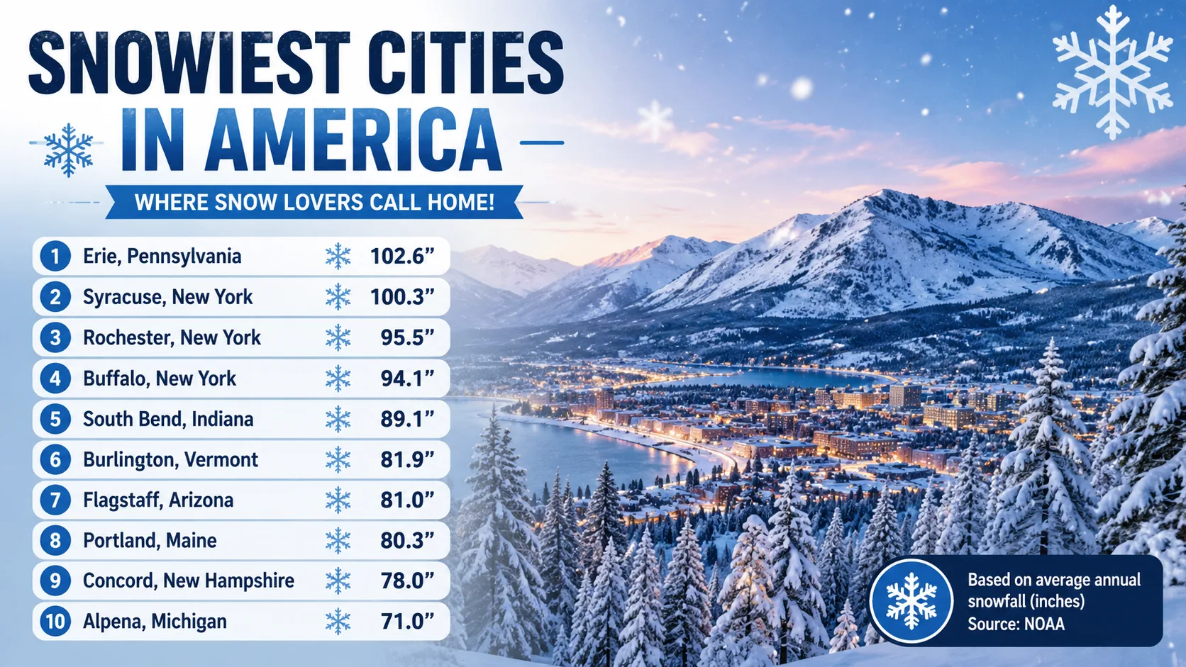
When people talk about the snowiest cities in America, they usually picture the same handful of names: Buffalo, Chicago, maybe Denver. The real rankings tell a different story.
Based on the latest 30 year NOAA climate normals, the snowiest cities in America are dominated by a cluster of Great Lakes cities most people rarely think about, plus a handful of high elevation towns that quietly catch more snow than anywhere else in the country.
This guide breaks down the real, data backed rankings, from the biggest metro areas to the smaller towns that actually top the list, explains why some places get buried in snow while nearby cities stay dry, and shows what those numbers actually mean in real life.
What Makes a City One of the Snowiest Cities in America?
Three ingredients need to line up before a place ends up on any real list of the snowiest cities in America. Cold air below freezing has to sit near the ground, moist air has to be available to form flakes, and something has to lift that moist air upward so it can condense.
That lifting mechanism is what separates true snow capitals from everywhere else. It usually comes from one of three sources: a large lake, a mountain range, or a coastal storm track.
How Snowfall Is Measured and Averaged
Every ranking in this guide uses NOAA climate normals, 30 year averages built from daily weather station data collected between 1991 and 2020. The National Centers for Environmental Information, or NCEI, recalculates these normals roughly once a decade.
A single snowy winter does not make a city one of the snowiest in the country. What matters is the long run average, since one record breaking storm can distort a single season without changing a city's true climate pattern.
Lake Effect Snow vs Elevation Snow vs Coastal Snow
Lake effect snow forms when cold, dry air moves across a large, relatively warm lake such as Lake Erie or Lake Ontario. The air picks up moisture and heat from the water, then dumps it as intense, narrow bands of snow the moment it reaches the colder shoreline.
This is why cities like Buffalo, Rochester, and Syracuse can receive dramatically more snow than cities just 30 or 40 miles further inland, away from the lake's direct path.
Elevation snow happens when moist air is forced upward by rising terrain, cooling as it climbs and releasing snow well before it ever reaches sea level. This is why Flagstaff, Arizona, sitting at nearly 7,000 feet, quietly out snows most of the Midwest despite being in a desert state.
Coastal and mountain storm tracks bring heavy, wet snow to places like coastal Alaska and parts of New England, where storms pull in enormous amounts of ocean moisture and slam it directly into nearby mountains.
Snowiest Cities in America: Top 10 Major Cities Ranked
Using NOAA's official climate normals for the largest U.S. metro areas, here is how the top major cities stack up for average annual snowfall.
Average Annual Snowfall, Top 10 Major U.S. Cities (inches) Rochester, NY 102.0 Buffalo, NY 95.4 Grand Rapids, MI 77.6 Cleveland, OH 63.8 Salt Lake City, UT 51.9 Hartford, CT 51.7 Minneapolis, MN 51.2 Boston, MA 49.2 Denver, CO 49.0 Milwaukee, WI 48.7 0 in 110 in
Data source: NOAA National Centers for Environmental Information, 1991 to 2020 climate normals, as compiled by Current Results for the 56 largest U.S. metro areas.
| Rank | City | Avg. Annual Snowfall |
|---|---|---|
| 1 | Rochester, New York | 102.0 inches |
| 2 | Buffalo, New York | 95.4 inches |
| 3 | Grand Rapids, Michigan | 77.6 inches |
| 4 | Cleveland, Ohio | 63.8 inches |
| 5 | Salt Lake City, Utah | 51.9 inches |
| 6 | Hartford, Connecticut | 51.7 inches |
| 7 | Minneapolis, Minnesota | 51.2 inches |
| 8 | Boston, Massachusetts | 49.2 inches |
| 9 | Denver, Colorado | 49.0 inches |
| 10 | Milwaukee, Wisconsin | 48.7 inches |
Notice how far the drop off is after the top two. Rochester and Buffalo sit in a class of their own among large metro areas, both fed directly by lake effect snow off Lake Ontario and Lake Erie.
Beyond the Big Cities: The Snowiest Towns in America
Once you remove the population cutoff used for major metro rankings, an entirely different set of towns takes over the top of the list. These smaller cities and mountain towns receive far more snow than any major metro area in the country.
| Town | State | Avg. Annual Snowfall |
|---|---|---|
| Valdez | Alaska | About 300 inches |
| Snyderville | Utah | 152.9 inches |
| Syracuse | New York | About 112 to 128 inches |
| Sault Ste. Marie | Michigan | 119.3 inches |
| Caribou | Maine | 114.2 inches |
| Marquette | Michigan | 108.7 inches |
| Erie | Pennsylvania | 104 inches |
| Flagstaff | Arizona | About 100 to 102 inches |
| Lander | Wyoming | 96.5 inches |
Figures compiled from NOAA NCEI climate normals as reported by Current Results, the National Weather Service Marquette office, and regional climate summaries. Syracuse and Flagstaff show a range because different measurement stations and reporting periods produce slightly different long term averages.
Current Results, which compiles NOAA snowfall data for towns across the country, describes Valdez as the snowiest town in the United States, driven by its coastal position at the base of the Chugach Mountains where moisture rolling off the Gulf of Alaska is forced sharply upward.
Snowiest Cities in America by Region
Grouping the rankings by region makes the pattern even clearer. Snow does not spread evenly across the country, it clusters into a handful of distinct belts, each driven by its own geography.
The Great Lakes Snowbelt
Rochester, Buffalo, Syracuse, Erie, Grand Rapids, Sault Ste. Marie, and Marquette all sit inside or near the Great Lakes snowbelt, the single most reliable snow producing region in the lower 48 states. Every one of these cities owes the bulk of its winter totals to lake effect bands rolling off Erie, Ontario, Michigan, or Superior.
The Mountain West and Interior
Salt Lake City, Denver, Snyderville, Lander, and Flagstaff all rely on elevation rather than a lake to generate snow. Storms moving through the Rockies, Wasatch, and San Francisco Peaks are forced upward, cooling rapidly and dropping snow well above 5,000 feet, often while nearby lower elevation valleys stay dry.
The Northeast
Boston, Hartford, Providence, and Caribou sit inside a corridor that regularly catches powerful coastal storms known as nor'easters. These systems pull enormous amounts of moisture off the Atlantic and can dump one to two feet of snow in a single 24 hour event, occasionally rivaling lake effect totals in a fraction of the time.
Coastal Alaska
Valdez stands almost entirely alone in this category. Its position at the base of the Chugach Mountains, directly exposed to moisture rolling off the Gulf of Alaska, creates a snow machine unlike anything else on this list, and unlike anywhere else in the country.
Notable Record Snowfall Events
Averages tell one story, but single storm records show just how extreme these cities can get. Buffalo has repeatedly made national news for multi day lake effect events that buried parts of the city under six or more feet of snow in a single storm, occasionally stranding residents and shutting down major highways for days.
Valdez has posted seasonal totals well beyond its long term average in strong years, with local reporting noting single season accumulations that pushed past 280 inches even before the winter had fully ended. Marquette, Michigan has also seen individual winters run tens of inches above its 30 year normal, a reminder that any single season can swing far above or below the long run average used in official rankings.
Putting the Numbers in Perspective
Raw inch totals can be hard to picture, so here is what these numbers actually mean on the ground.
- Rochester's 102 inches a year is roughly the total height of a one story house across an entire winter, even though it never all sits on the ground at once because of melting, settling, and plowing.
- Valdez's 300 inches a year would stack two and a half standard 10 foot basketball hoops on top of each other if every flake landed and stayed exactly where it fell.
- Flagstaff's roughly 100 inches a year happens in a state most famous for cactus and desert heat, proving that elevation can matter just as much as latitude when predicting snowfall.
Why These Cities Get So Much Snow
The Great Lakes snowbelt exists because of a simple temperature gap. Lake water cools much more slowly than land, so well into December and January the lakes stay warmer than the air crossing over them.
As cold Canadian air sweeps across that relatively warm water, it absorbs moisture and rises, forming clouds that dump heavy snow the instant they reach the colder shoreline. Areas directly downwind of a lake, like Buffalo east of Lake Erie, can see dramatically more snow than towns just a short drive away.
Mountain and elevation driven snow works differently. As air is forced upward over rising terrain, it cools and loses its capacity to hold moisture, wringing out snow well before reaching the peak. That is exactly why high altitude towns like Flagstaff and Snyderville rack up totals that rival much colder, flatter regions.
Snowiest States vs Snowiest Cities
City rankings and state rankings often tell different stories. A state can post a modest overall average while still containing one extraordinarily snowy town.
Alaska is the clearest example. The state includes Valdez, the single snowiest town in the country, alongside vast interior and northern regions that receive comparatively little snow because the air there is simply too cold and dry to produce heavy totals.
Vermont, New Hampshire, and Michigan tend to rank near the top of statewide snowfall averages because a larger share of their land area sits inside consistent snowbelt or mountain zones, rather than depending on one or two exceptionally snowy towns to pull the average up.
Read More : Cold Day Calculator
Benefits and Downsides of Living in a Snowy City
Benefits:
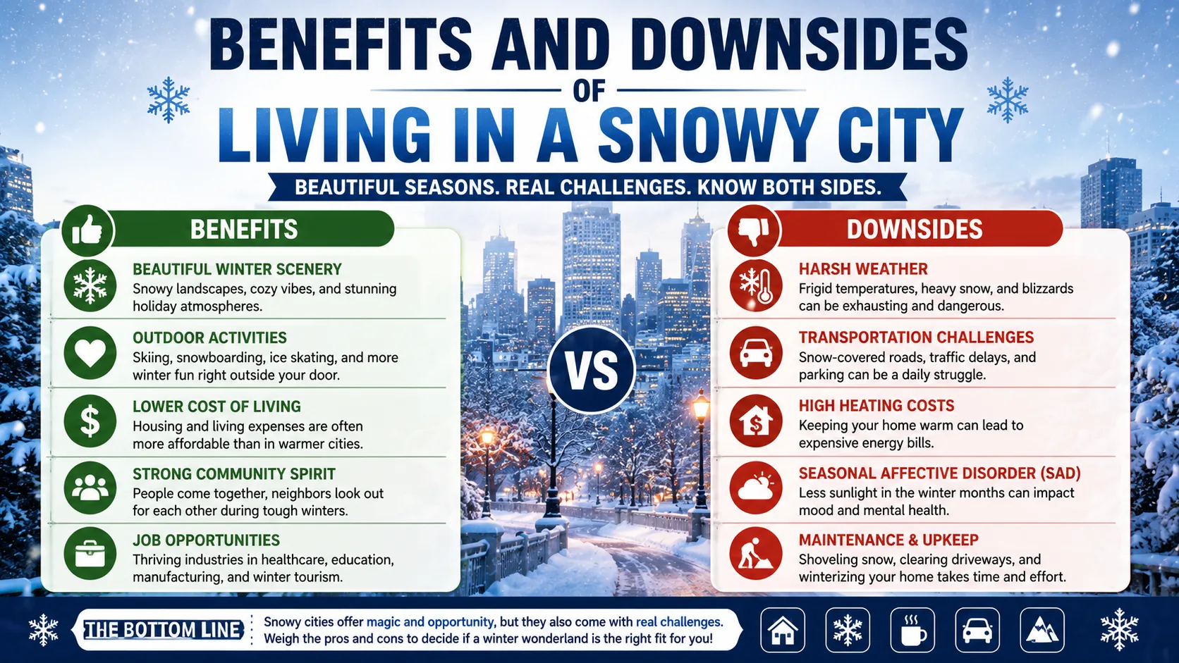
- Easy access to winter recreation. Skiing, snowboarding, snowshoeing, and sledding are often a short drive, or even a walk, from home in towns like Snyderville or Marquette.
- Reliable mountain snowpack. Elevation driven snow feeds reservoirs and rivers that many western states depend on for drinking water and agriculture through spring and summer.
- Stable property demand. Established ski and lake effect towns tend to attract steady buyer interest year after year, supporting long term home values.
- Scenic, four season landscapes. Many residents genuinely enjoy the visual and emotional shift a real winter brings compared to year round mild climates.
- Milder summers. Cities with heavy winters often trade extreme summer heat for comfortable, temperate conditions the rest of the year.
Downsides:
- Higher home maintenance costs. Snow removal equipment, roof raking, ice dam prevention, and winterized plumbing all add ongoing expense.
- More hazardous commutes. Icy roads and reduced visibility during lake effect bursts increase accident risk and, in some regions, insurance premiums.
- Higher heating bills. A long, consistently cold season means furnaces and heat pumps run far more often than in milder climates.
- Mood and routine impact. Extended stretches of gray, snowy weather can affect daily routines and energy levels for some residents.
Common Misconceptions About America's Snowiest Cities
- "The coldest cities get the most snow." Not true. Snowfall depends on moisture as much as cold, so extremely cold but dry regions can actually receive relatively little snow.
- "Alaska is uniformly the snowiest state." One coastal town, Valdez, skews perception. Much of interior and northern Alaska receives far less snow than popular assumption suggests.
- "More snow days automatically means deeper snowpack." Frequency and total volume are different metrics. A city can see snow often while still totaling fewer inches than a place with fewer, heavier storms.
- "Coastal cities always get less snow than inland cities." New England disproves this regularly, since nor'easters can dump feet of snow on coastal communities in a single storm.
- "Big cities always get less snow than small towns." Population size has nothing to do with snowfall. Rochester and Buffalo are proof that a sizable metro area can sit directly in a snowbelt and out snow far smaller towns just a short distance away.
Tips for Moving To or Visiting One of the Snowiest Cities in America
- Check the specific snowbelt map, not just the city name. Snowfall can vary by 20 or more inches within the same metro area depending on distance from a lake or elevation.
- Budget for snow removal from day one. Plowing, roof raking, and driveway clearing add up fast in a true snowbelt city.
- Invest in real winter tires, not just all seasons. Lake effect and elevation snow cities see far more low traction days than the national average.
- Ask about roof snow load ratings before buying in a heavy snow zone, especially in older homes.
- Plan travel with buffer time from November through March, since lake effect bursts can shut down roads with very little warning.
Conclusion
The real list of the snowiest cities in America looks very different once you set assumptions aside and follow the actual NOAA data. Among major metro areas, Rochester and Buffalo stand well above the rest, both fueled by intense lake effect snow off the Great Lakes.
Once smaller towns enter the picture, the ranking flips again, with Valdez, Alaska towering over every other place in the country thanks to its coastal, mountain fed snow machine. Even a desert state like Arizona has its own snow capital in Flagstaff, proof that elevation can rewrite the rules just as easily as latitude.
Whether you are planning a move, researching winter recreation, or just settling a debate about which American city really earns the title of snowiest, the numbers tell a clearer story than reputation alone ever could.
Also Checkout :